
[Update Friday Jan. 16]: Chances for accumulating snow over the MLK weekend have increased for downstate NY and southern New England. See Forecast for details.

No real base within a couple fo hours of the NYC metro. Although cooler weather is entering the region, upcoming snowfall is expected to be scant and a bit scarce. To see what’s up, read on. This post is about conditions for Jan. 15, and forecast for the next few days. See jump links to Conditions and Forecast.
How’s the skiing in general?
There’s a fine line between slush and sheer ice. We’re just on the right side of it this morning.
– Rikert Outdoor Center conditions report Jan. 15
Tuesday to Thursday have been trainsition days for the weather, with warmer temps and a bit of rain or wintry mix, plus snow. It’s been waxless skis, Maxiglid, and klister for classic skiing till now. Midweek is good timing for the kind of drastic weather change we’re about to have.
In the lucky northern areas, rain converted over to snow, leaving 1-3″ of new, wet snow. Once again, the Tug Hill and Adirondacks made out OK, along with the higher elevations of the Northern Green Mountains. As for the valleys and southern Vermont, it’s a matter of hwo much rain they got and how good their grooming is. Such are the times where the heroes shine.
Soft conditions with the wet snow up north, and loose granular in the lower elevations and south. Crust underneath the new snow motivated some areas to do a bit of light grooming to set tracks, others to hold off till Thursday evening or Friday. As the air turns colder, the trails will get firmer and faster. Expect some touch up grooming Friday in preparation for the holiday weekend.
Off-piste skiing is likely to have been a bit tough with hard and crusty snow. It will be better if topped off by some heavier snow . BETA report of 1/15 says: ‘The warm spell has ended with 2-3″ of new wet snow as of Thursday evening. We had hoped the first snow would be wet so that it would stick to the crust underneath. Now we can hope for the inch or two of new lighter snow predicted for tonight into tomorrow.’
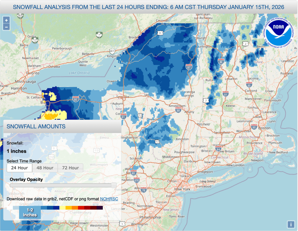
Hit up ‘State of the touring centers‘ or in the menu above for reported conditions as of today. Snow depth and 24hr snowfall graphics below:
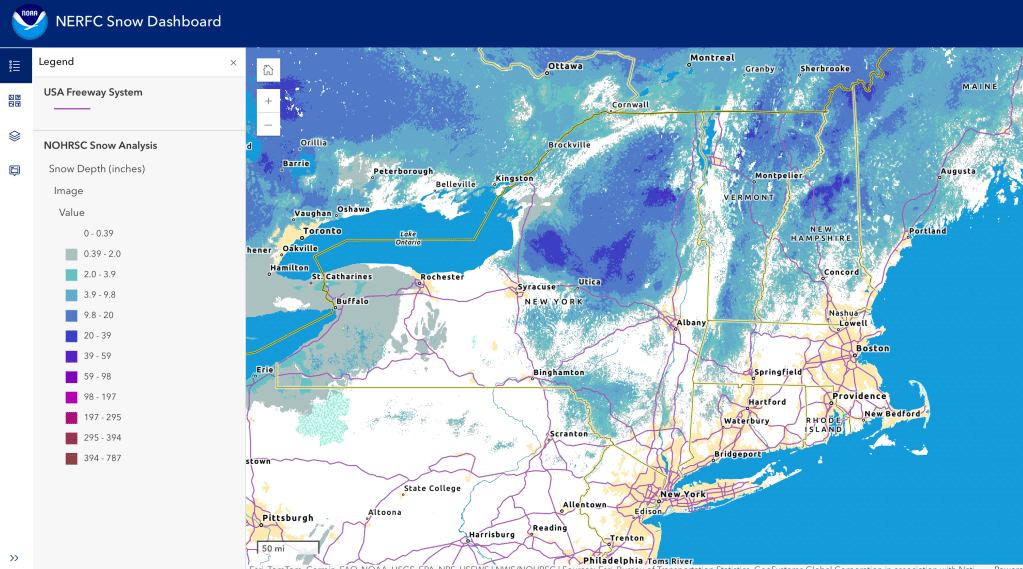
Oh, to be in Vermont! Or the Adirondacks; the Tug Hill; or maybe Buffalo or Rochester…
Forecast
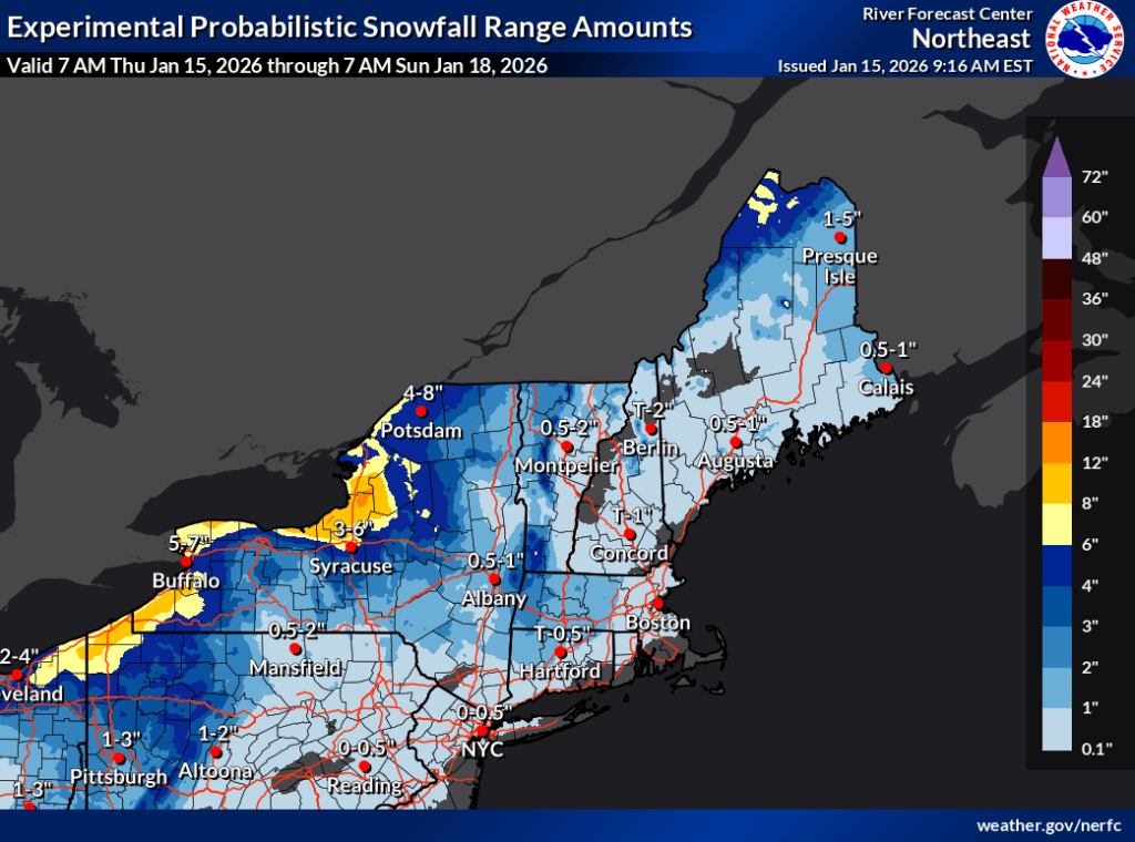
[Update Friday Jan. 16]: Moderate chances of 1-2″ of snow tonight for inland downstate NY area (including Hudson Valley). Accumulations could be up to 3″ for Albany and southern Vermont. Another system late Sunday could bring another couple of inches of snow to coastal areas of NY and New England.
We’re about to get a taste of the polar vortex lashing us with a stream of cold air. We’ll see a ten-degree drop in daytime highs on Friday, and by next Monday or Tuesday the high temps will be 20 degrees colder than today (Thursday).
In addition to cooling temps, the area from Albany and Massachusetts southward can expect wind gusts of 25+mph from tonight through Thursday midday. Dress warm.
Those touring centers that have snowmaking will start up the snowgguns as early as tonight. Prospect Mountain has snowmaking and groomers to move the white stuff. High Point has some kind of snowmaking set up, but it hasn’t been used very much.
Unfortunately there’s no major snowstorms in sight to help everyone out. The better news is that a few smaller systems and lake-effect snow are going to drop an inch or a few on the far northern areas and Tug Hill, and may do so repeatedly over the weekend and toward the middle of next week. It won’t be a lot of snow, and it now looks like it will affect probably won’t make its way toward the NYC metro. In any case the weekend forecast is enticing for a trip north for the MLK weekend.
Winds will be mild with light breezes through most of the weekend, and pick up on MLK Day with some gusts of 20-25mph along the coasstal areas of the northeast. Isolated gustiness will continue more generally across the northeast for Tuesday and Wednesday.
Regional snowfall likelihood:
- The Tug Hill and western New York can expect repeated lake effect snow over the next week. Some bitter wind chills will also accompany the colder temps and breezes off the lakes.
- The Adirondacks and northern Vermont may also benefit from some lake effect snow or other snow showers, particularly Friday-Saturday and early next week
- Southern Vermont and the Albany area could see a bit of snow over the next few days with accumulation of a few inches possible.
- The NYC metro and downstate region will probably see a bit of snow tonight and in the latter part of the weekend, but amounts are uncertain.
| Date | Northern NY VT NH mtns | Northern lowlands | Hudson Highlands to NYC metro |
| Th 1/15 | 20s | 30s to low 40s | Mid 30s to low 40s |
| Fr 1/16 | Single digits to teens | Low 20s | Low 30s |
| Sa 1/17 | Teens to low 20s | 30s | Upper 30s to low 40s |
| Su 1/18 | Teens to low 20s | Low 20s to low 30s | Low to mid 30s |
| Mo 1/19 | Single digit to teens | Teens to mid 20s | Low 30s |
| Tu 1/20 | Below zero to single digits | Single digits to teens | Low 20s |
| We 1/21 | Below zero to single digits | Teens | 20s |
