
Minnewaska is hanging on, and Prospect Mountain has spring skiing conditions. The general word is that it would have been best to go out during the midweek period because it’s about to get warm and rainy.
This post is about conditions for Jan. 8 2026, and forecast for the next few days. See jump links to Conditions and Forecast.
How’s the skiing in general?
One touring area recommended waxless skis, or using the ‘k’- word wax:

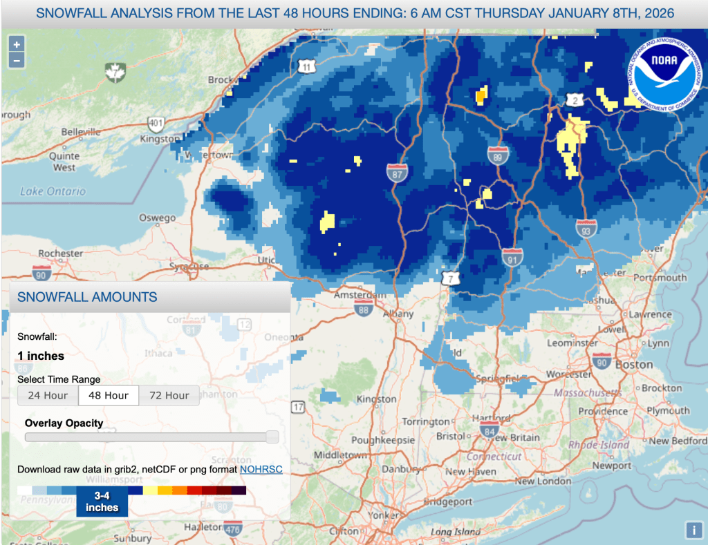
In the southern and lower elevation areas, trail conditions are loose, wet, and granular. Upstte NY and northern New England got several inches a couple of days ago, much of which seemed to be wet snow on top of a breakable crust. With expectations of rain, several touring areas are closing trails for the next couple of says to preserve the base. Most seem to be expecting better conditions by Sunday.
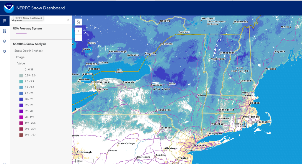
Hit up ‘State of the touring centers‘ or in the menu above for reported conditions as of today. Snow depth and reent snowfall graphics below:
Regular refreshes of snow are always welcome but are especially important when temperatures may go above freezing and some rain is in the forecast. BETA report of 1/6 agrees. For details read on.
Forecast
Friday morning, fog in eastern New England. By the afternoon rain showers overspread the northeast, with heavier rain toward the southern and eastern coasstal regions. Gusty winds in the far north, possibly reaching 50+mph.
Showers break briefly on Saturday, giving way for another system bringing precipitation, working its way northward. Cooler temperatures may make this more snow showers up north, but it won’t be cold enough for a copnversion to snow south of the Adirondacks and Vermont or New Hampshire. Precipitation will continue through Sunday before tapering off late in the evening. Expect wind gusts to abate for the weekend.
The southern and NYC metro area could see so,me 20+mph wind gusts on Monday, before winds calm down for the rest of the week. Lake effect snow on Tuesday portends yet another system with snow and rain starting Wednesday and lasting into Thursday. Probably snow and rain showers with mostly snow north of the Hudson Highlands and downstate region.

| Date | Northern NY VT NH mtns | Northern lowlands | Hudson Highlands to NYC metro |
| Fr 1/0 | Upper 30s | Mid 40s | Mid 40s to low 50s |
| Sa 1/10 | Upper 20s | Mid to upper 30s | High 30s to high 40s |
| Su 1/11 | 20s | 30s | High 30s to high 40s |
| Mo 1/12 | Teens | 20s | High 30s to low 40s |
| Tu 1/13 | Low 20s | Mid 30s | Low to mid 40s |
| We 1/14 | Low 20s | Mid 30s | Low to mid 40s |
| Th 1/15 | Teens | 20s | Mid 30s to low 40s |
