
[Update 2025-1225 1300h] It’s time for downstate NY skiers to get some winter love from Mother Nature. For the holiday weekend your ski window extends from now till sometime late Sunday 12/28 or early Monday 12/29. The ideal ski outing window is from Saturday morning to Sunday afternoon before rain starts in earnest. See additional details in Forecast below.
I had intended to update the lat post with updated info, but there’s so much it really deserves a separate post:
- Anywhere from 2-8″ of new snow fell across the north country from the Adirondacks to the Whites, making for a much merrier-lookingChristmas than just a few days ago.
- Better news is yet to come for the holiday weekend, with a storm that will drop the majority of its snow toward the west of NYC and Hudson Valley.
There may not be any XC ski centers open for skiing within a few hours of NYC right now, but that may well change by Saturday morning. This post is about conditions for Ded 24 2025 and forecast for the next few days. See jump links to Conditions and Forecast.
How’s the skiing in general?
The heayweight touristed areas were ready: Craftsbury, Trapp Family Lodge, Lapland Lake, Jackson Ski Touring, and Waterville alley all seemed to be ready to catch some luch and have (ahem) rolled-out the skiing carpet. Some of the lesser-known spots like Scotts Cobbble, Paul Smiths VIC, and Rikert were also game to make a go of Christmas Eve grooming. BETA report of 12/24 reports the High Peaks backcountry area got a few inches, and snow cover is status quo ante as of a week ago.
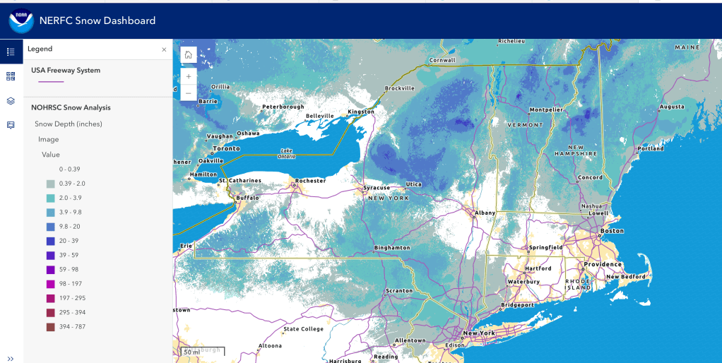
Hit up ‘State of the touring centers‘ or in the menu above for reported conditions as of today. Snow depth graphic below shows an unusual split in snow cover, with a large gap in the Albany area and Berkshires.
Forecast
Windy Wednesday. Light snow falls Thursday morning in the far northern areas. Gusty winds in the southern parts of the northeast.
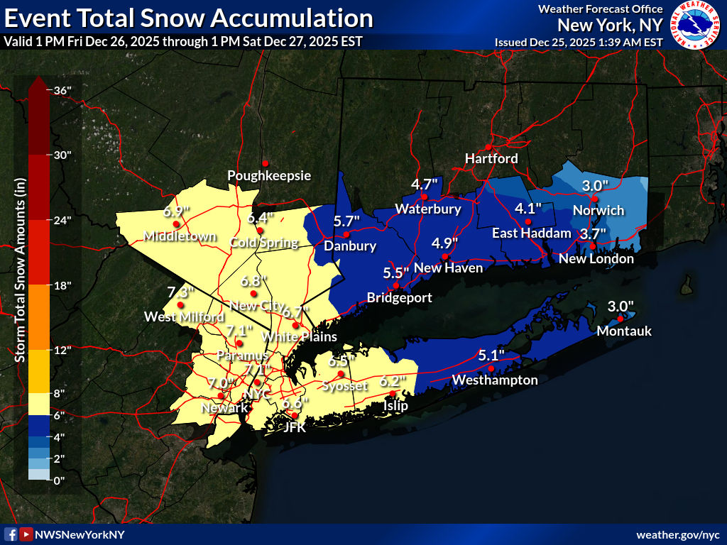
[Update 2025-1225 1300h] Greatest snow accumulation area for Friday evening storm has shifted slightly north and east. Friday night snowfall totals could reach 8″ or more around the Delaware Water Gap and eastern Catskills. NYC and the coastal area of LI Sound could see 6″ by early Saturday morning. The Hudson Highlands including Fahnestock, Minnewaska, and Mohonk should receive a very useful refresh 7-8″ of new snow. Winter Storm Warning in effect for Greene and Ulster counties in NY (Catskills and New Paltz area); Winter Storm Watch in effect for Middlesex county NJ (High Point State Park), NYC, portions of coastal CT and LI.
[original post] Bands of snow arrive in the region midday Friday. continuinig through Friday night. Light snow and wintry mix on Saturday. Gusts up in the north country could exceed 40mph. The surprise is that by 7am Saturday the 27th there’s a. 60-70% chance of more than 4′ of snow from the NYC area to th northwest along the NY-NJ border to the Delaware Water Gap. High Point will be pleased, because the colder temperatures Friday and Saturday will help keep the snow around.
Update 2025-1225 1300h] Updated snowfall accumulation forecast indicates significant amounts for the NYC metro and Hudson Highlands extending up to the Catskills. The fairly narrow target of heavy accumulation could leave the Berkshires. southern Adirondacks, and southern Vermont with only get a minor refresh.

Downstate high temps well above freezing for Sunday and Monday. Precipitation will continue through Sunday into Monday, unfortunately as rain in the NYC/coastal areas, and a combo of snow/wintry mix/ice in the interior lowlands and far north., Seasonably cooler temps and drier on Tuesday, but also windier than the weekend.
Northern areas of NY State and New England: [AI generated summaries]
- Light to moderate snow and snow showers Christmas Day, particularly in higher terrain (Adirondacks, Bolton area, Mt. Washington region), followed by a very cold, windy night with sub‑zero mountain lows and single digits to lower teens in many lowlands.
- Mountains: Snow or mixed snow/sleet/freezing rain developing Sunday PM, especially Adirondacks, Bolton, Whites; then widespread snow/snow‑mix Monday with significant new accumulation potential and strong winds at higher elevations.
- Lowlands: More rain or rain/snow mix Sunday PM into Monday, with a changeover toward snow as colder air crashes in. Travel/grooming impacts likely region‑wide.
Southern regions and NYC metro: [AI generated summaries]
- Wednesday-Thursday: cool with occasional mixed precipitation
- Storm system Monday
- Coastal areas: mostly rain
- Inland / higher terrain: mix → snow
- Windy everywhere with a sharp temperature drop late
- Tuesday brings colder air and scattered snow showers inland, with the coast drying out.
| Date | Northern NY VT NH mtns | Northern lowlands | Sourthern regions & NYC |
| Th 12/25 | 20–30 / −8–0 | 30–35 / 0–10 | 34–46 / 20–32 |
| Fr 12/26 | 4–18 / 2–8 | 15–25 / 10–20 | 28–40 / 18–28 |
| Sa 12/27 | 15–29 / 5–9 | 25–35 / 13–20 | 30–42 / 16–26 |
| Su 12/28 | 23–33 / 20–24 | 32–36 / ~30 | 36–48 / 22–34 |
| Mo 12/29 | 28–32 / 5–15 | 33–35 / 12–30 | 38–52 / 28–36 |
| Tu 12/30 | 10–17 / 5–10 | 18–23 / 10–15 | 30–40 / 20–28 |
