
It’s a quick-turn reversal in weather so well known in the region – warming trend, a low that brings rain/wintry mix, followed by dip in termperatures back below reezing. This is clearly not the stocking stuffer we were hoping for. The aftermath has left us with no XC skiing within at least four hours of NYC.

This post is about conditions for Dec. 20 2025, and forecast for the next few days. See jump links to Conditions and Forecast.
How’s the skiing in general?
Many areas closed up Friday, and as of today the ones with cover are working on trails that froze up after rain and sometimes a few inches of snow. A handful of areas managed to scratch out a few kilometers of skiable terrain. Sunday may be better, as the groomers break up and smooth out the cover.
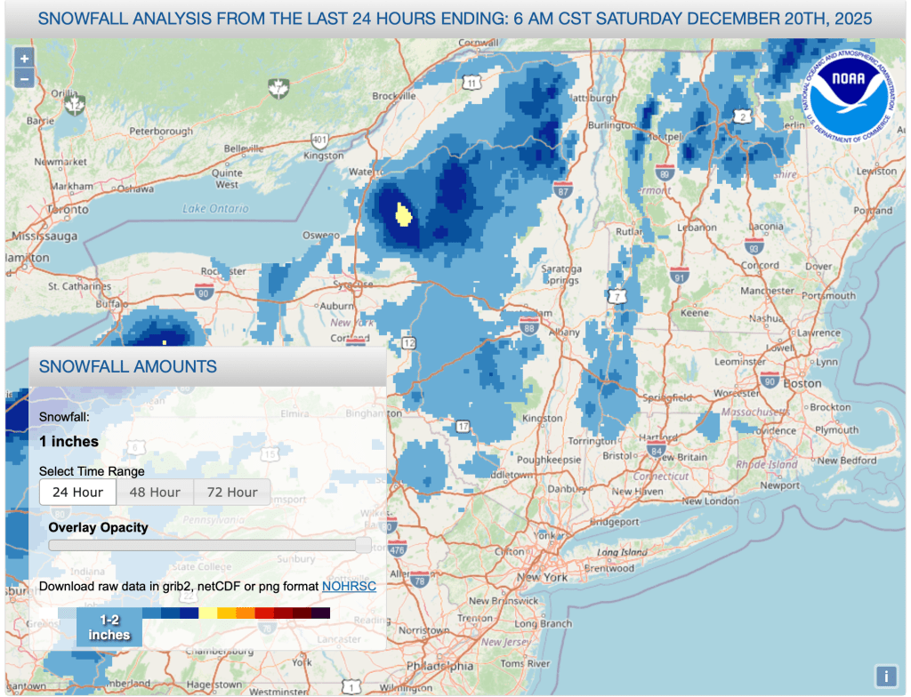
The Tug Hil, High Peaks, and higher elevations of the northern Green and White Mountains made out best from the changeover of precipitation Friday:
There could be a few days of decent skiing in the first part of the holiday week, but warming temperatures and a weather system late in the week will put some coal in the stocking for Dec. 25. BETA report of 12/20 says conditions are ‘hard and fast’, and they’re expecting a warm-up late in the week.
Hit up ‘State of the touring centers‘ or in the menu above for reported conditions as of today. Snow depth graphic below shows that the scant snowfall didn’t do much to improve the coverage:

Forecast
Possible light snow and lake effect snow mainly for central and northern NY State. Seasonably cool tempertures and mild winds across the region. Light lake effect driven snow in upstate NY and the Tug Hill.
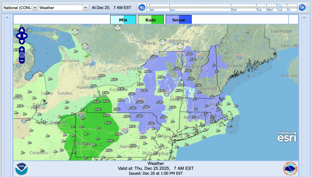
LIght snow and wintry mix begin late Monday night into Tuesday. Heaviest snowfall central and northern NY and New England. There’s a possibility for a few inches of snow accumulation in lowlands and several inces in northern and elevated terrain. Southern areas will see wintry mix turning over into rain before the system moves out by Wednesday. Temperatures begin warming for the remainder of the Christmas week.
Another system coming rom the west enters the region Christmas Eve and continues through the end of the week. This will bring some isolated wind gusts and rising temperatures for the Christmas holiday. An associated low will cause precipitation, principally as rain except in the farthest northern and highest elevations.
Northern areas of NY State and New England: [AI generated summaries]
- Mountains (Adirondacks, Greens, Whites, Tug Hill high terrain)
- Frequent snow, especially Dec 20–21 and Dec 23–24
- Lowlands (Burlington, Syracuse, Glens Falls, valleys near ski centers)
- Highs: upper 20s–40s, occasionally near 50°F (Dec 24)
- More mix events vs pure snow
Southern regions and NYC metro: [AI generated summaries]
- Inland (MA, NH, CT, NY, NJ parks)
- Frequent snow chances, especially Tue–Wed.
- Coastal (NYC, Long Island, Boston)
- Highs upper 30s–40s, occasionally near 50 midweek.
- Rain/mix events mainly Tue–Wed.
| Date | Northern NY VT NH mtns | Northern lowlands | Sourthern regions & NYC |
| Su 12/21 | 20–35 / 5–15 | 30–44 / 10–30 | 26–46 / 14–34 |
| Mo 12/22 | 12–22 / 2–15 | 18–40 / 5–26 | 18–42 / 6–32 |
| Tu 12/23 | 20–28 / 12–25 | 23–42 / 18–30 | 24–48 / 14–36 |
| We 12/24 | 18–33 / 10–23 | 21–50 / 14–32 | 30–52 / 20–40 |
| Th 12/25 | 22–31 / 10–25 | 28–40 / 20–30 | 32–44 / 18–33 |
| Fr 12/26 | 13–37 / 4–16 | 20–40 / 10–20 | 22–42 / 13–28 |
