
Well heck yeah, that’s the way to start winter – High Point, Minnewaska, and Mohonk are all either still open or were able to reopen after a surprising refresh of snow last Sunday. Bonus – NYC got enough snow to make people watch and wonder:

By now things have degraded a bit due to warmth, and rain tonight will probably kill the skiability of snow cover downstate until another storm. C’est la vie, and hope. you had fun while it lasted.
This post is about conditions for Dec. 18, and forecast for the next few days. See jump links to Conditions and Forecast.
How’s the skiing in general?
As the saying goes: ‘don’t like the weather? Just wait a minute’.
The continued cold last week through the early part of this week, and a modest refresh of snow on the weekend brought us to ‘mid-winter skiing’ conditions till Tuesday. The quick upturn in termperatures has meant spring skiing midweek. Tonight we see rain and then icy trails by Friday night as temperatures cool off once again.
If we’re lucky, some places just north of Albany will have enough cover remaining and be able to groom it up by Saturrday or Sunday. Check with areas before going. Strong or gusty winds could cuase other hazards on the roads. What’s coming next? Check the forecast below.
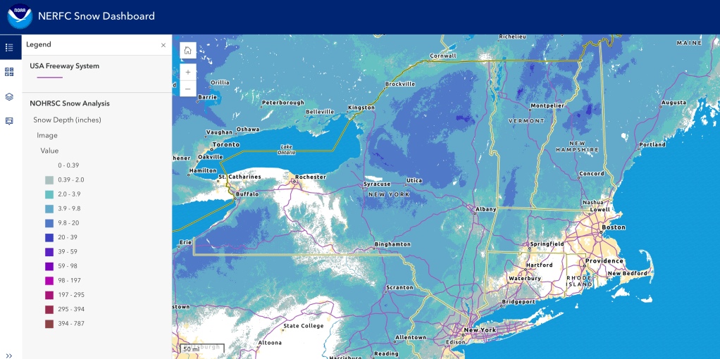
Hit up ‘State of the touring centers‘ or in the menu above for reported conditions as of today. Snow depth graphic below:
Forecast
Rain arrives tonight starting from the west and working eastward. The entire northeast will see moderate to heavy rain by Friday morning. Best chance for some precipitation to convert to snow happens Friday evening, mainly in upstate New York and isolated parts of nrothernmost New England.
If you can bear with clicking through the triptych below, you can see the spread of rain expected, the changeover to snow in the late afternoon, and the possible remaining areas of snowfall later in the evening. (double-click the graphic to see the group one-by-one in larger view. Probably works better on a larger-screen device)


Cooler weather arrives on Friday and stays for the weekend, and small lows may also bring light snow Sunday for northern NY and New England.
Possible light snow in northern New England during the first part of next week, with rain for southern New England and the NYC metro.
There are indications of a storm system that may be impactful next week in the midweek but too much uncertaintly at the moment for any prediction.
Northern areas of NY State and New England: [AI generated summaries]
- Mountains (Adirondacks, Greens, Whites, Tug Hill):
- Highs mostly in the teens–30s, lows single digits or below zero.
- Frequent snow showers, especially Thursday, Saturday, Sunday, and Tuesday–Wednesday.
- Lowlands (Burlington, Syracuse, Glens Falls):
- Highs upper 20s–40s, occasionally near 50 midweek.
- More variability with rain/mix events, especially Saturday and Wednesday.
Southern regions and NYC metro: [AI generated summaries]
- Temperature spread:
- Coldest stretch: Friday–Monday, with inland lows near/below 10°F and highs only in the 20s.
- Storm potential: Tuesday night into Wednesday brings widespread snow inland and rain/mix along the coast.
| Date | Northern NY VT NH mtns | Northern lowlands | Sourthern regions & NYC |
| Fr 12/19 | 12–22 / 0–10 | 22–34 / 12–22 | 22–44 / 12–34 |
| Sa 12/20 | 20–30 / 10–18 | 30–40 / 18–28 | 28–48 / 18–36 |
| Su 12/21 | 422–32 / 12–20 | 32–44 / 20–30 | 26–46 / 14–34 |
| Mo 12/22 | 15–25 / 5–12 | 25–38 / 15–26 | 18–42 / 6–32 |
| Tu 12/23 | 20–28 / 10–18 | 30–42 / 18–30 | 24–48 / 14–36 |
| We 12/24 | 25–35 / 15–22 | 35–48 / 25–36 | 30–52 / 20–40 |
