
Kind of amazing that eighty-four years have passed since the Pearl Harbor attack on a Sunday morning of the same date. As much room as there is for a nostalgic callback, we should also acknowledge that the day and the war that followed took place four generations ago. Maybe lives and events since then – the good, the bad, and the WTF – are also worth some space in the narrative.
And now, back to our regularly scheduled programming. Where can a downstate NY’er go skiing?
- Minnewaska State Park still has ‘fair to very good’ conditions with most trails groomed
- Mohonk Mountain House trails are open and groomed but no tracks have been set.
- River-to-Ridge trail is showing gravel and is a multi-use trail. Potentially skiable but definitely bring your oldest, most worn-out skis.
Last year a massive Thanksgiving snowstorm just north of the mid-Hudson allowed Minnewaska to open on Dec. 5, but skiable conditions in the downstate part of the regionwere short-lived. This time conditions should allow skiing to last longer. This post is about conditions for Dec. 7 2025, and forecast for the next few days. See jump links to Conditions and Forecast.
In a sdder note the owners of Canterbury Farm have called it a day after 40 years and decided to retire. So no cross-country skiing at this charming little B&B in the Berkshires. See more in this article at this article at Boston.com
How’s the skiing in general?
BETA report of 12/5 says ‘BEST EARLY SEASON SKIING IN YEARS’, but goes on to caution that the base is thin, and “every lump of snow that sticks up should be assumed to be a rock until proven otherwise.”
A few more places have opened up for the sason as of this weekend, but for areas further south and lower in elevation, conditions are becoming marginal without a refresh of snow. A potential refresh may be in the offing for next seek. See forecast.
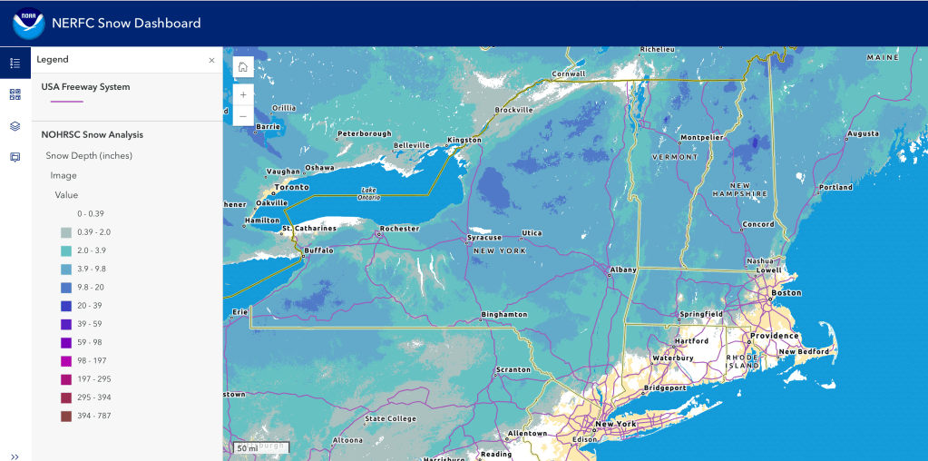
Hit up ‘State of the touring centers‘ or in the menu above for reported conditions as of today. Snow depth graphic below:
Forecast
Cool weather stays around through the weekend, and light snow showers and lake-effect snow will spread across northern NY State and New England Sunday evening into early Monday. Accumulations will be slight for the most part, less than 1″.
Cold and blustery conditions will prevail on Monday, and precipitation will move out late Monday for a drier Tuesday, before another system making its way through the region Tuesday evening. Small ‘clipper’ systems are forecast into the latter half of the week. Southwesterly winds bring warming temperatures Wednesday that will cause a changeover of any precipitation from snow to rain/wintry mix, with a change back towards more snow as cooler temps arrive for Thursday and Friday.
Altogether these ‘Canadian clipper’ systems in the latter half of the week could bring scattered snow for a few days, with another system possible for next Friday or Saturday.
Highlights for Northern areas of NY State and New England: [AI generated summaries]
- Storm Potential:
- Sunday night into Monday: Snow event in mountains, mix in valleys.
- Tuesday night–Wednesday: Widespread snow/rain system across the region.
Highlighs for Southern regions and NYC metro: [AI generated summaries]
- Cold Snap: Sunday night through Monday is the coldest stretch, with inland lows near/below 10°F and coastal lows in the 20s.
- Storm Potential: Tuesday night into Wednesday brings the next widespread snow/rain system across the region.y.
| Date | Northern NY VT NH mtns | Northern lowlands | Sourthern regions & NYC |
| Su 12/7 | 13–25 / -1–5 | 28–40 / 20–28 | 31–42 / 17–28 |
| Mo 12/8 | 11–15 / -9–2 | 24–40 / 18–25 | 18–33 / 2–21 |
| Tu 12/9 | 21–26 / 13–19 | 31–40 / 20–28 | 24–42 / 21–31 |
| We 12/10 | 28–33 / 17–23 | 31–50 / 25–32 | 34–49 / 27–41 |
| Th 12/11 | 26–31 / 10–15 | 34–40 / 20–30 | 32–44 / 18–33 |
| Fr 12/12 | 15–26 / 5–10 | 20–34 / 10–20 | 22–42 / 13–28 |
