
This is when you see the ski touring center operators start waking up. They dust off their keyboards and start up the snow groomers, make an update on the site about opening or why they’re not open, and sometimes start grooming a bit. As a result, about half the sites have updates from a today or a few days ago, while the other half are still dormant, showing whatever they left there last April.
This post is about conditions for Dec. 1 2025, and forecast for the next few days. See jump links to Conditions and Forecast.
How’s the skiing in general?
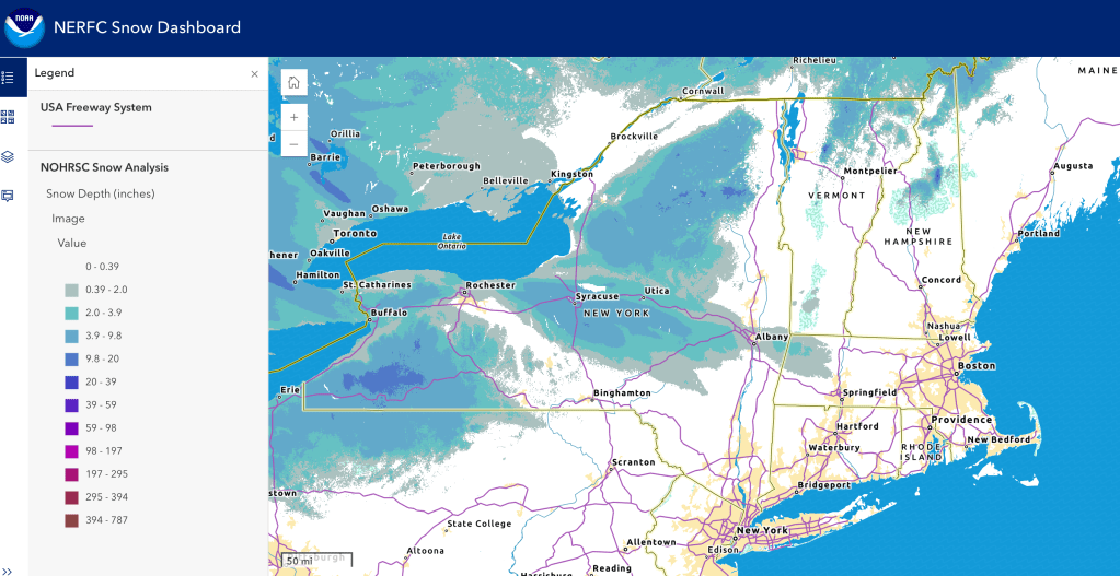
Lapland Lake has a bare 1k open, and Mt van Hoevenberg, Rikert, Craftsbury, and Trapp have minimal terrain available. The warm spell last week took out a lot of the cover out of the backcountry. Not wonderful but it’s still technically November as I write. Hit up ‘State of the touring centers‘ or in the menu above for reported conditions as of today. Snow depth graphic below:
Forecast
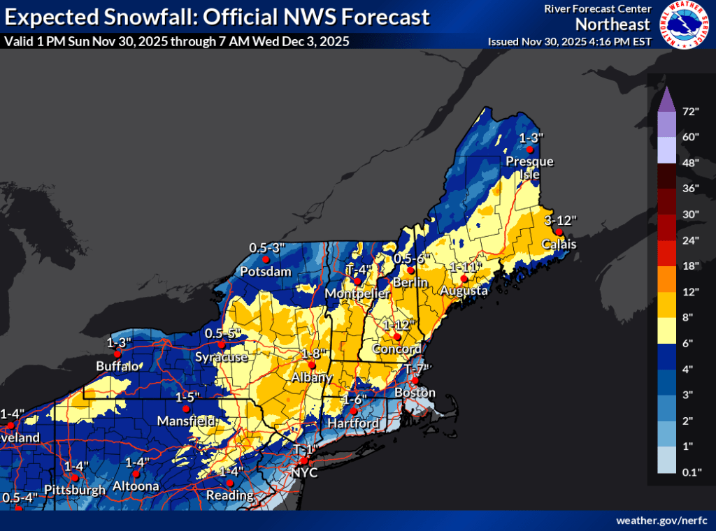
A low pressure system bringing moisture is due to head up the Atlantic coast starting Monday. Meanwhile a high arrives in the region from the west bringing cold weather. They’ll meet early Tuesday morning, causing rain along the coast and snow inland. Expect hazardous road conditions for the commute.
Current predictions are that the rain/snow line will be align roughly with I-84, with maximal snow band across the Catskills, Berkshires, mid- and southern Vermont and New Hampshire including the White Mountains. This is subject to change with any shift in the predicted storm track. Accumulations could be 6-12″ in one scenario, 2-4″ in another. This Nor’easter will be around only for the day, but this is the first real snowstorm of the season.
The image below shows a wide swath to be impacted early this week, and a wide range of accumulations due to sensitivity of outcome to the exact track of the weather system.
When all is said and done, there could be some skiing a bit closer to the downstate NY region by Wednesday. With cold temps due to come in later in the week, and another possible storm for the weekend, there’s a chance for cross-country skiing next weekend.
Northern areas of NY State and New England: [AI generated summaries]
- Major storm Tuesday (Dec 2): Heavy snow in NH Whites (4–8″), Tug Hill (3–5″), Adirondacks 2–4″. Burlington/Glens Falls may see rain/snow mix.
- Cold snap Thursday night–Friday: Mountain lows near 0°F, highs only upper teens/low 20s.
- Weekend: Snow showers linger Saturday–Sunday, but lighter. Conditions improve with partly sunny skies.
- Lowlands vs Mountains: Lowlands (Syracuse, Burlington, Glens Falls) run 5–15°F warmer than mountain sites (Marcy, Bolton, Jackson NH).
Southern regions and NYC metro: [AI generated summaries]
- Major storm Tuesday (Dec 2): Inland regions (Dublin NH, Northfield MA, High Point NJ) expect 5–11 inches of snow, while coastal NYC, Riverhead, and Boston see rain (1–2 inches).
- Cold snap Thursday night–Friday: Inland lows drop to single digits (9–11°F), highs only in the low 20s. Coastal lows stay in the 20s, highs upper 30s.
- Weekend outlook: Saturday brings scattered snow inland and rain along the coast. Sunday moderates, with inland highs near 30°F and coastal highs near 50°F.
| Date | Northern NY VT NH mtns | Northern lowlands | Sourthern regions & NYC |
| Mo 12/1 | 24–33 / 13–25 | 325–41 / 21–27 | 32–42 / 21–29 |
| Tu 12/2 | 29–33 / 16–22 | 30–41 / 23–30 | 29–48 / 19–28 |
| We 12/3 | 28–31 / 18–19 | 31–50 / 24–32 | 31–41 / 21–30 |
| Th 12/4 | 28–33 / 0–3 | 32–40 / 20–25 | 32–44 / 9–30 |
| Fr 12/5 | 19–20 / 7–8 | 21–29 / 12–16 | 21–38 / 15–25 |
| Sa 12/6 | 30–31 / 10-15 | 30–35 / 15–18 | 31–44 / 22–29 |
| Su 12/7 | 28–29 / 13–20 | 28–35 / 20–28 | 30–50 / 22–41 |
