
Too early to break out in song, but the NOAA Climate Prediction Center has issued an advisory that oceanic conditions met the criteria for a ‘weak’ La Niña effect on winter weather this season. See article at the Weather Chabnnel site with the unreasonably long title La Niña Has Developed In The Pacific Ocean And Will Persist Through Winter. Here’s What That Means. for the story.
What is a La Niña?
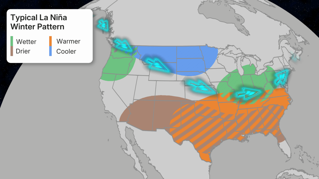
The La Niña (and its counterpart El Niño) are names given to a recurrence of surface temperature patterns in the Pacific Ocean near the equator which, when correlated with other oceanic and atmospheric effects, lead to a shift in the flow of the Jet Stream among other things. It’s important to know that these contrasting temperature patterns are just one of several seasonal variations. They just happen to be measurable and correlative to seasonal winter weather patterns of temperature and precipitation in North America.
The weather impacts of El Niño, La Niña, and marine conditions producing them are described here:
- https://ocean.si.edu/planet-ocean/el-nino-explained-understanding-forces-shaping-2023-24-winter-weather.
- https://oceanservice.noaa.gov/facts/ninonina.html
What does this bode for the upcoming winter?
It turns out that there’s a difference in outcome for ‘weak’ La Niña winters vs moderate or strong, and a weak one is the kind predicted by NOAA. Weak La Niñas have been found to result in ‘above-average snowfall across much of the northern tier of the U.S., from the Cascades of the Northwest through the upper Midwest and New England. Whereas below average snowfall typically occurs in the southern Rockies and parts of the Ohio Valley.’ (see Weather Channel article)
What’s happened in previous La Niña winters?
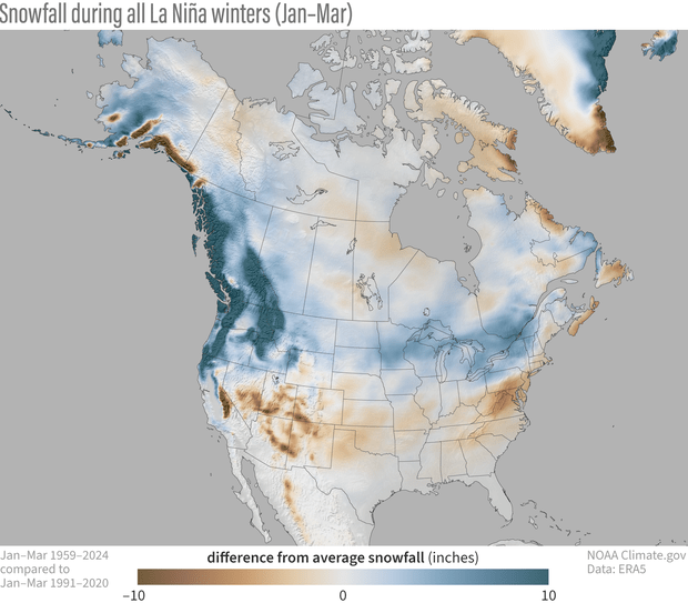
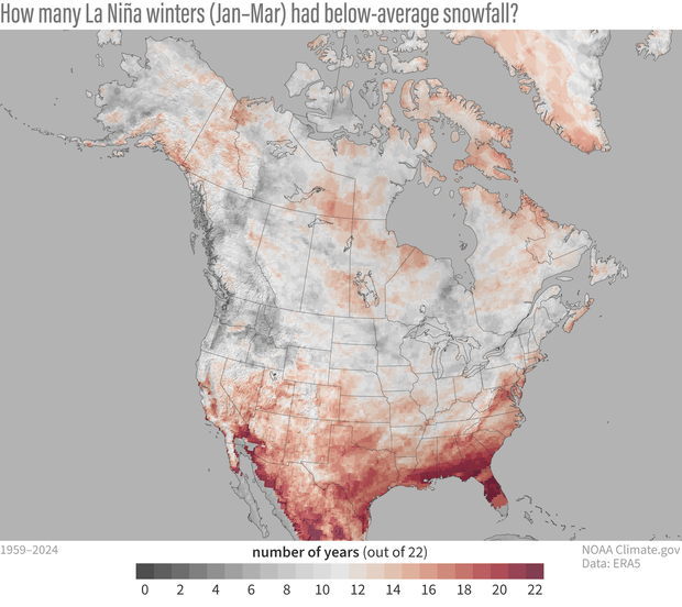
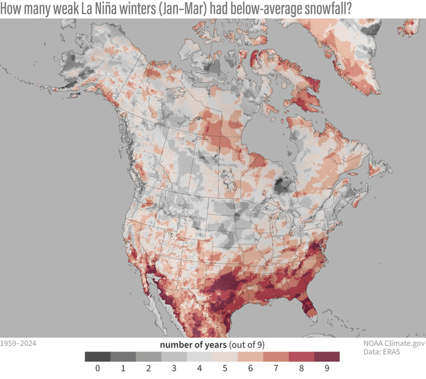
In a piece on on the NOAA website climate,cgov, a set of color illustrated maps show two different perspectives on the pattern of snowfall for North America. They show that in general a La Niña produces much more snowfall than normal over the Pacific Northwest, and somewhat greater than average snowfall in the midwest and Great Lakes regions; and b) it rarely results in below-avearage snowfall for the Pacific Nortwest, while the chances are about even for the northeast US. See Revisiting La Nina and winter snowfall (published October 2024).
One map below shows where above-average snowfall occurred (redder is worse, bluer is better). It is paired with a map of the number of times a La Niña year preduced below-average snowfall (redder is more frequent, greyer is lesser in number:
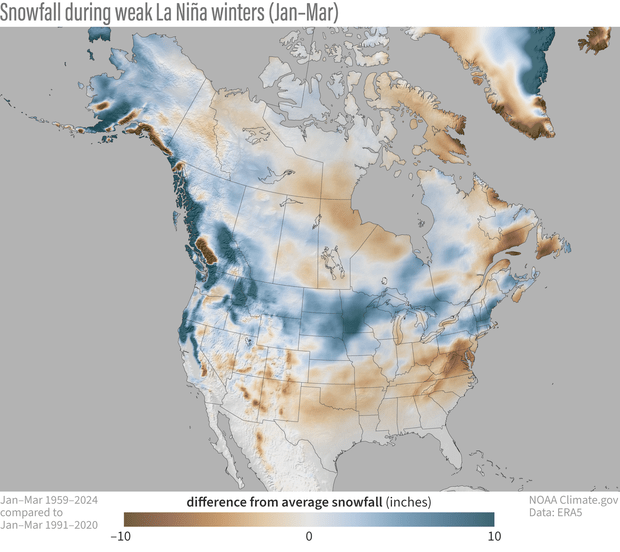
Now for weak La Niñas – comparing the two sets for regular vs weak La Niñas shows that a weak La Niña is associated with more evanly distrubted above-average snowfall than across the midwest and northeast US, and likewise a somewhat less than 50-50 chance of below average snowfall across the northern tier of the lower 48 (and in the northeast).
This kind of work is nerdism of the highest order – not only do you look for predictive, testable correlations, you validate by testing or checking for the opposite of the predicted condition. And you set a time range for data that’s relevant for what you’re trying to measure.
More reent history
Back in Novemer of 2024, the Climate Prediction Center called for a weal La Niña period lasting into the January-March period: https://www.weather.gov/arx/winter2425outlook, and it turned out to be a pretty decent if not spectacular winter in the northeast US. Certainly it was cold enough, but skiers in the northeast would have apprecated a bit more snowfall.
In May of 2024, the National Weather Service recapped the winter of 2023-24, saying it was a reversion to El Niño after three La Niña years: https://www.weather.gov/media/buf/Winter_Summary_2023_24.pdf. Posts in this blog from mid-February and early March of the 23-24 season are skiing-related validation of a season where we had to be ready to jump at even marginal skiing conditions.
For a deeper dive into how climate scientists judge what’s ‘normal’ in a dynamic system, see this update regarding the end of the La Niña of 2023-24: https://www.climate.gov/news-features/blogs/enso/april-2025-enso-update-la-nina-has-ended
What about predictions for this winter?
The Climate Prediction Center at NOAA believes it’s somewhat likely that the La Niña will revert to normal (ENSO-neutral) from January to March, which could change the game for our winter. In other words, we might have a good start but sputter on in the heart of the season. Rats to that, but way to early to clutch pearls.
And just anote that all this research and data is provided by the federal government for the public good – or at leat it was. Hmm – maybe there’s a damp spot in my undies after all.
