

This post is about conditions for March 12 2025, and forecast for the next few days. See jump links to Conditions and Forecast.
How’s the skiing in general?
With the warm weather and the snow turning to corn, the early mornings meant frozen granular ‘fast and firm’ conditions, before transitioning to wet granular by late morning. The meltwater makes skiing slower due to suction, but the warm temps are so comfortable, it’s a treat. Some people ski in shorts on days like this.
Wednesday we’ll experience a drop in temperatures that will keep trails frozen a bit longer- in the northern areas, conditions might stay ‘fast and firm’ through most.of the day. Despite that, the next few days offer a chance for great spring skiing, as long as you pick the right spot- one where the snowpack and grooming are in good shape. Backcountry should be pretty nice too, at least at elevation.
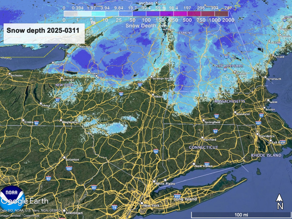
Hit up ‘State of the touring centers‘ or in the menu above for reported conditions as of today. Snow depth graphic below:
Forecast
The fat guy could be warming up in the wings for the finale. General warming trend through this week, and a significant rainstorm expected on the weekend could do a lot of damage to the snowpack as well as causing floods from meltwater runoff.
If the snowpack holds where you are or at the spot you choose, there’s some beautiful spring skiing to be had until the end of the week. Get it in before Sunday. Here’s what to expect from the weather:
- Wednesday daytime remains dry. Southerly flow of air begins Wedesday night bringing warmer temperatures and with it a possible shower to downstate NY. Northern NY and New England will have seasonable temperatures on Wednesday just ahead of a warming trend. Gusty winds across the White Mountains and northern New Hampshire.
- Thursday – Friday: Thursday will begin a warming trend, Small chance of rain/snow showers on Thursday, and dry on Friday. Winds should be mild.
- Saturday-Sunday: A large and deep low-pressure system will bring southerly flow and rain across the region by late Saturday, with heavy rain forecast for most of the northeast on Sunday. Amounts expected in the 1/2″-1″ range.. Temperatues will be warm enough to match levels seen in November of last year. As a result, significant melt-off of the snowpack is expected. While winds will be light in general, portions of region could see gusts of 25-30mph starting Saturday night, and wider areas may see gusts of 35-40mph on Sunday.
- Monday – Tuesday: Cooler than the weekend but still above seasonal norms. Rain may extend into Monday. Wind gusts moderate on Monday, and drier air moves in for Tuesday.

| We 3/12 | Th 3/13 | Fr 3/14 | Sa 3/15 | Su 3/16 | Mo 3/17 | Tu 3/18 | |
| Northern NY, VT, NH – Daytime temps | High 20s to low 40s | Low to mid 40s | High 40s to low 50s | Mid to high 50s | High 50s to mid 60s | Mid 40s to low 50s | Mid 40s to low 50s |
| NYC metro and southern New England coastline – Daytime temps | Mid 40s to low 50s | Mid to high 40s | High 40s to low 50s | Mid to high 50s | High 50s to mid 60s | 50s | 50s |
Thanks for reading Take a day off to go skiing!
