
Upper Awosting at Minnewaska and Overcliff trail at Mohonk are hanging on as skiable, although last grooming may have been a few days ago. Ski it or lose it.
Conditions have suffered from the warm spell of the last few days. Many areas held off grooming today (Wednesday), and a few closed trails hoping for a better tomorrow that may actually come this weekend.
This post is about conditions for Feb.26, 2025, and forecast for the next few days. See jump links to Conditions and Forecast.
How’s the skiing in general?
Spring skiing conditions – soft and damp during the days. With overnight temps above freezing in the last couple of days, the trails haven’t been ‘frim and fast’ in the mornings, but that will change by Friday north of the I-90 corridor. There’s still a pretty good base in most locations, and even Great Brook near Boston has skiable conditions.
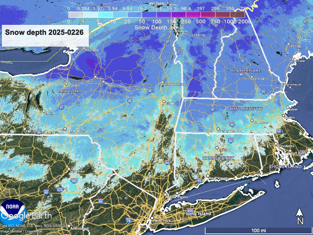
[Updated Feb. 27] Look for frozen/loose granular conditions this weekend, with a coating of fresh snow by end of day Saturday. Hit up ‘State of the touring centers‘ or in the menu above for reported conditions as of today. Snow depth graphic below:
Forecast
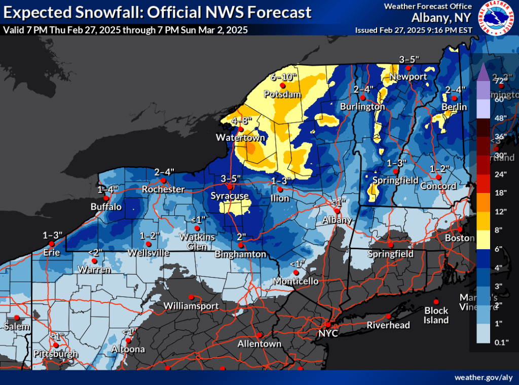
[Updated Feb. 27] No major storms coming, but gusty winds Thursday and Friday, becoming blustery over the weekend. Temperatures will flip back and forth from warmer to cooler, but precipitation expected for Thursday will mostly fall as rain or change over from snow to rain or freezing rain. Another system makes it’s way through staring overnight Friday and during the day Saturday. Daytime temperatures will bottom out at midwinter-like levels on Sunday. Bullets by area:
- Downstate NY and NYC metro: Light rain Wednesday night into Thursday. Another shot of rain likely Friday late and Saturday. Winds become blustery during the weekend, with gusts of 35-30mph.
- Albany region and southern VT, NH: Precipitation could result in a few inches of wet snow by Thursday morning. Some changeover to freezing rain/ice or rain in southernmost areas and lower elevations. Friday and the weekend will be much cooler than before. Some light precipitation possible, mostly as rain.
- Northern NY, VT: Brief snow showers or squalls possible overnight into Thursday, with fluffier snow possible in the early part of the weekend. Altogether could be several inches in some isolated spots, but mostly ust an inch or three. Isolated areas with gusty winds on the weekend.
- Tug Hill and central NY: A few inches of lake effect snow possible over the next coupld of days, but also expect rain from the minor systems coming through the region.
[Updated Feb. 27] The northeast will be dry from the latter part of the weekend into the early part of next week, after which a system could bring rain or snow. Looks like a warming trend for the middle of the week though, with some precipitation by Wednesday. Stay tuned.
| Th 2/27 | Fr 2/28 | Sa 3/1 | Su 3/2 | Mo 3/3 | Tu 3/4 | We 3/5 | |
| Northern NY, VT, NH – Daytime temps | Low to mid 40s | High 20s to high 30s | Mid 30s to mid 40s | Teens to mid 20s | Low 20s to low 30s | Mid 30s to low 40s | 40s |
| NYC metro and coastal New England – Daytime temps | 50s | 40s | High 40s to mid 50s | High 20s to mid 30s | Mid 30s | Mid 40s | 50s |
