
Of the ski touring centers close to NYC, only High Point reports trails are open for skiing.
- High Point: Open. Grooming in progress to break up frozen snow/ice and clear debris.
- Fahnestock: No skiing due to insufficient snow cover.
- Mohonk: No skiing due to high winds and icy trees.
- Minnewaska: The park is closed Monday due to icy roads and paths.
This post is about conditions for Feb. 17 2025 and the next few days. See jump links to Conditions and Forecast.
How’s the skiing in general?
Tons of snow up north, anywhere from 10-16″. Light glaze or ice on snowpack all across the northeast, but seems worse toward the western points of interest (Tug Hill) and south of Vermont and New Hampshire. High winds in open aras are causing windblown snow, falling branches, and of course a risk of exposure. Skiing in the woods generally recommended. Trails will be crusty or wet depending on locale and state of grooming.
Some places are closed due to winds or icy snow, but most are open, probably after having gotten up super-early to groom, because it’s a holiday and they don’t want to miss the business. Pineridge near Albany is often a bit marginal due to lack of snow, and they’re also open although not grooming today.
Backcountry skiing could be very challenging, with a hard breakable or unbreakable icy crust. Some extra hazards from windblown snow masking what lies beneath. Might need to let the weather warm up and decompose the snowpack a bit toward the end of the week.
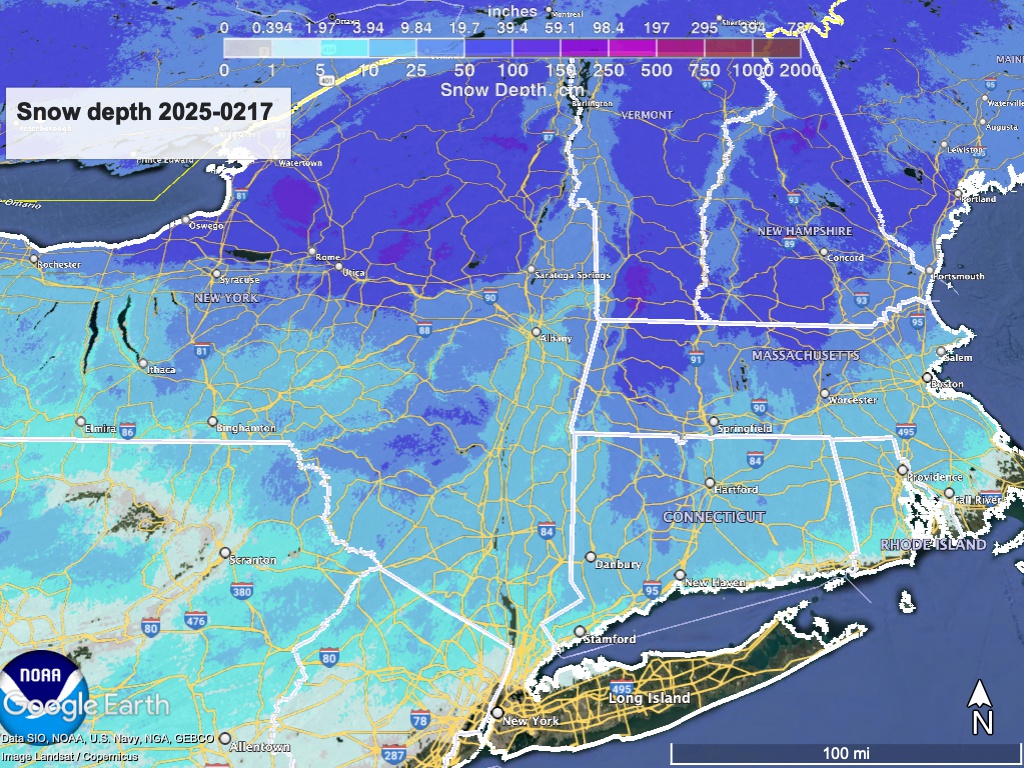
Snow depth graphic below shows excellent coverage at elevation:
Forecast
Very strong gusty winds today, with temperatures becoming very cold. The forecast for the week in broad strokes by area:
- Significant lake effect snow will sweep across central NY State and the Mohawk valley through Monday, including the southern Adirondacks and Vermont. The immediate area east of the Great Lakes could see another 1-2 feet of snow.
- Quite cold for the start of the week, with strong gusty winds that could reach 45-50mph. Bring that buff and ski in the woods. Watch out for debris on the trails, and falling branches.
- A system will drive moisture into the NYC and downstatte region late Wednesday into Thursday, and exit quickly. This could leave an accumulation of snow in the south, but the speed and extent indicates it won’t be very much.
- Winds die down after Wednesday. Temperatures will become milderr with a warming trend through the weekend, but it’ll still be wintry enough for good snow conditions.
| Mo 2/17 | Tu 2/18 | We 2/19 | Th 2/20 | Fr 2/21 | Sa 2/22 | Su 2/23 | |
| Northern NY, VT, NH – Daytime temps | Teens to low 20s | Single digits to teens | Teens to low 20s | Low to mid 20s | 20s | Mid 20s to low 30s | High 20s to low 30s |
| NYC metro and coastal New England – Daytime temps | Mid 20s to mid 30s | 20s | 20s | Mid to high 20s | 30s | 30s | Mid 30s |
Have a great holiday week.
