
So yeah, we got punk’d down south. But the High Peaks, Northeast Kingdom, and White Mountains made out pretty well.
If you’re already up north, you will proobably find some decent conditions by Monday afternoon. Further south, keep smiling, and hope for some snow on Thursday.

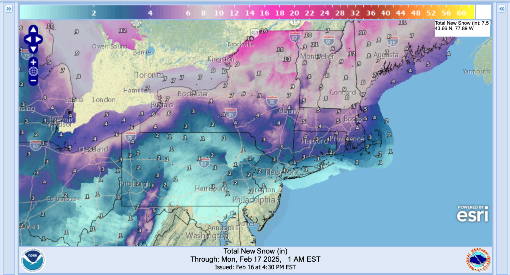
This post is about conditions for Feb. 16 2025 and forecast for the next few days. See jump links to Conditions and Forecast.
How’s the skiing in general
‘All over the map’ if you’ll allow the pun. In broad strokes by area:
- Downstate: Snowpack has been washed out or thinned too much for skiing. Magic 8 Ball says ‘ask again later’. Holding out hope for a system coming late in the week.
- Catskills, Berkshires, Albany region and southern Vermont: Conversion of snow to freezing rain and rain made the trails soggy. Cold temps and wind overnight will both dry them out and freeze them, so there will be. abit of work to do on Monday to groom things out. Cold gusty winds could make driving hazardous.
- Southern Adirondacks, Central Vermont: Snow conditions are fair to decent, but road conditions might make driving hazardous.
- High Peaks, Northeast Kingdom, White Mountains: A bit of freezing rain it sounds like, but mostly snow, so conditions should be good by Monday late morning.
- Tug Hill: Lots of rain on the snowpack. Might take some work to groom it out, but there’s a good base and the forecast calls for a ton of lake effect snow tomorrow.
The issue heading out into the week is if the trails are slushy, they’ll freeze up into a dense crust or bulletproof ice. Backcountry skiing could be pretty tough to manage. Hit up ‘State of the touring centers‘ or in the menu above for reported conditions as of today.
Forecast
Continued snow in the northern areas, with very strong gusty winds. Temperatures will begin falling later tonight and flash-freezing is a real concern. Drivers be careful tonight!. Forecasts for the week in bullets:
- The northern areas of NY State and Vermont have seen 5-10″ of snow, and could get another 2-5″ tonight.
- Significant lake effect snow will sweep across central NY State and the Mohawk valley through Monday, including the southern Adirondacks and Vermont. The immediate area east of the Great Lakes could see another 1-2 feet of snow.
- Quite cold for the start of the week, with strong gusty winds that could reach 45-50mph. Bring that buff.
- A system will drive moisture into the NYC and downstatte region overnight Wednesday to Thursday, and exit quickly. This could leave an accumulation of snow, but the speed and extent indicates it won’t be very much.
- Winds die down after Wednesday. Temperatures also get milder toward the end of the week and next weekend, but still wintry enough for good snow conditions.
| Mo 2/17 | Tu 2/18 | We 2/19 | Th 2/20 | Fr 2/21 | Sa 2/22 | Su 2/23 | |
| Northern NY, VT, NH – Daytime temps | Teens to low 20s | Low teens to low 20s | Teens to low 20s | Low to mid 20s | Low 20s to low 30s | Low 20s to low 30s | High 20s to low 30s |
| NYC metro and coastal New England – Daytime temps | Mid 20s to low 30s | 20s | 20s | Mid to high 20s | 30s | 30s | Mid 30s |
