
At least one and maybe two storms could bring what downstate XC skiers have been hoping for1

Meanwhile, things north of the Catskills and I-90 are about as good as they can be.
This post is about conditions for Feb. 7 2025, and forecast for the next few days. See jump links to Conditions and Forecast.
How’s the skiing in general?
Pretty great, even though yesterday’s system may have made waxing classic a bit harder today, with a slight glaze on the snowpack. Snowfall from yesterday shows a nice refresh of 3-4″ primarily across the northern Adirondacks, Green, and White Mountains:

Hit up ‘State of the touring centers‘ or in the menu above for reported conditions as of today. Snow depth graphic below:
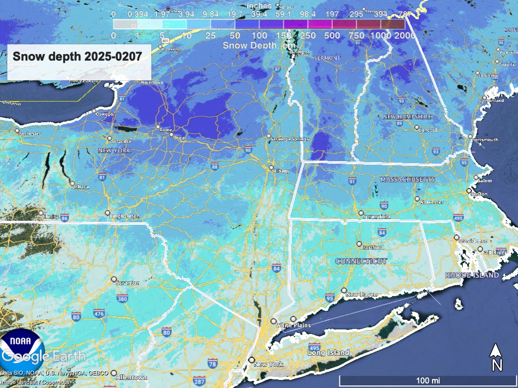
See that slight amount of cover, maybe 1-2″ across the triangle of southern NY and the tristate area? That’s what we hope will look a lot better by Sunday morning.
Forecast
For the next seven days, another three-system week of weather is in store. As bullets:
- Snow Saturday night and into Sunday. Heavier and wtter down south, light and fluffy up north. Greatest accumulation favorable for areas across the Catskills and southern New England. Hudson Highlands and Shawangunks are close enough to catch some of this. Accumulations for northern Adirondacks and New England will be modest.
- Light snow Tuesday. Currently predicting all snow, some accumulation but amount uncertain, depending on whether the system consolicates or becomes multiple small systems.
- Snow or rain/snow mix Wednesday night into Thursday. Track uncertain as to whether the center will pass over the northeast meaning more rain than snow, versus further south which would mean more snow.
Breezy today, with gusts in the NYC metro of 30-35mph. Further north gusts cout go 50+mph. Overall winds will be light, with gusts around 15mph for the weekend, and also on Monday, Tuesday, and Thursday.
For this weekend’s weather event, accumulation in the far north is expected to be less than the Capital region and southern VT, but an excellent addition to the 3-5″ they got yesterday:

The band of greatest predicted snowfall (8″+) runs along an ESE line from Oswego through Albany and Boston:
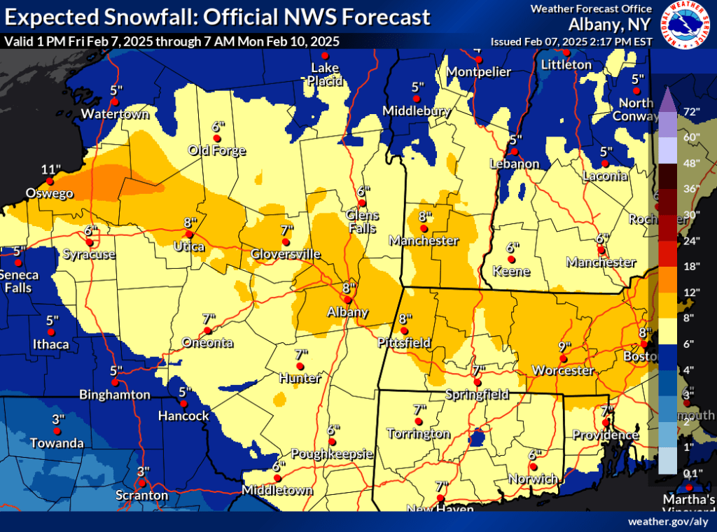
The Tug Hill plateau could see a foot of snow, and areas like Lapland Lake and Garnet Hill can also expect several inches. Pine Ridge, Notchview, and other areas in western MA will finally get their due, and Great Brook will likely do much better than ‘scrape by’ on thin cover after.Saturday night.
Of course for the downstate NY’ers we’re looking for those precious few inches that will put decent cover on thin to zero base. The forecast accumulation could be 6-8″ or so for the mid-Hudson region, and somewhat less for northwest NJ.

The table of temps for the upcoming week:
| Friday 2/7 | Saturday 2/8 | Sunday 2/9 | Monday 2/10 | Tuesday 2/11 | Wednesday 2/12 | Thursday 2/13 | |
| Northern NY, VT, NH – Daytime temps | Mid 20s to low 30s | 20s | Mid 20s to low 30s | Teens to high 20s | Mid 20s to low 30s | High 20s to low 30s | 20s |
| NYC metro and coastal New England – Daytime temps | High 30s to low 40s | 30s | 30s | High 20s to mid 30s | High 20s to mid 30s | 30s | 30s |
