
How’s the skiing going to be?
Today’s weather might just be enough for Minnewaska trails to be skiable, but not to reopen trails at Fahnestock or High Point. However, things are ooking up for the skiability of trails at all three following the storm due to come through on Saturday night.
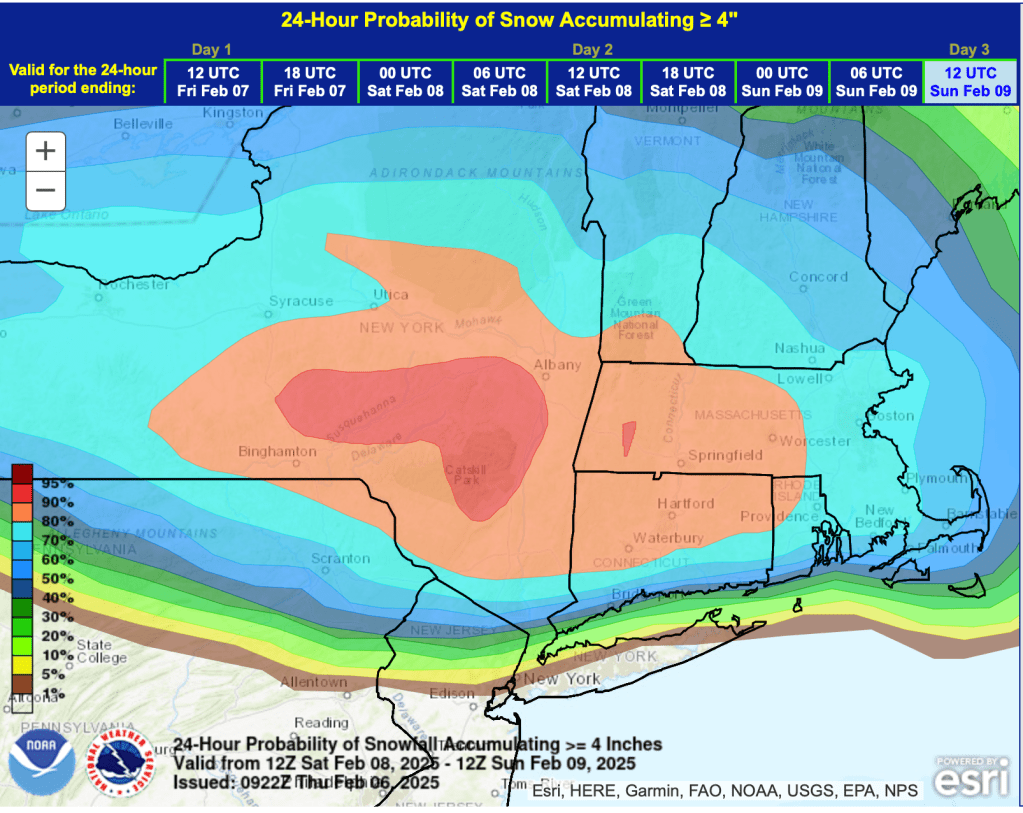
The weekend weather will bring snow to the southern inland region of NY and New England. Probability of more than 4″ of snow in the 24 hours preceding 12noon Sunday shows very high likelihood concentrated around the Catskills down to the Hudson Highlands.
Specific forecasts
Forest trails and multi-use paths will also benefit, depending on cover remaining. National Weather Service forecasts for the closest touring centers to NYC:
Fahnestock State Park (Carmel, NY)
Today:
Snow and sleet, possibly mixed with freezing rain before noon, then freezing rain likely between noon and 3pm, then a slight chance of rain after 3pm. Patchy fog after 3pm. High near 33. Wind chill values between 15 and 25. Southeast wind 5 to 9 mph, with gusts as high as 20 mph. Chance of precipitation is 100%. Total daytime ice accumulation of less than a 0.1 of an inch possible. Total daytime snow and sleet accumulation of 1 to 3 inches possible.
Saturday night:
Snow before 4am, then snow and sleet. Low around 25. Chance of precipitation is 100%. New snow and sleet accumulation of 5 to 9 inches possible.
(5 to 9 inches – be still my beating heart!)
Minnewaska State Park Preserve (Kerhonkson, NY)
Today:
Snow and sleet before noon, then snow and sleet likely, possibly mixed with freezing rain between noon and 1pm, then freezing rain likely after 1pm. The snow could be heavy at times. High near 33. Southeast wind 5 to 7 mph becoming southwest in the afternoon. Chance of precipitation is 100%. Little or no ice accumulation expected. Total daytime snow and sleet accumulation of 1 to 3 inches possible.
Saturday night:
Snow. Low around 23. Chance of precipitation is 100%.
High Point State Park (Montague, NJ)
Today:
Snow, freezing rain, and sleet before 3pm, then a chance of rain between 3pm and 4pm. Patchy fog after noon. High near 34. Southeast wind around 5 mph becoming southwest in the afternoon. Chance of precipitation is 80%. Total daytime ice accumulation of less than a 0.1 of an inch possible. Total daytime snow and sleet accumulation of 1 to 3 inches possible.
Saturday night:
Snow likely before 10pm, then snow, possibly mixed with freezing rain. Low around 22. Chance of precipitation is 100%. New precipitation amounts between a half and three quarters of an inch possible.
