
Downstaters, there’s hope for a bit of snow to enliven the weekend. How much will be snow, vs wintry mix or rain? Up north, light snow has already begun.
Backstory: on February. 3, Minnewaska State Park reported: “We were down to crusty ice and gravel on the trails, but we received about two inches of snow last night [Feb. 2] that groomed up pretty well. There will be some thin conditions out in spots, especially the windy/exposed cliff sections of Castle Point and Hamilton Point carriage roads.”. By now the trails will be back to where they were on Saturday. But a few inches tonight could make a ky difference.
If we luck out, The Shawangunks and High Point will get a badly-needed refresh of snow. Magic 8 Ball says ‘ask again later’.

This post is about conditions for Feb. 5 2025, and forecast for the next few days. See jump links to Conditions and Forecast.
How’s the skiing in general?
Up north today is a bluebird kind of day where it’s not snowing. Blue or green wax if you’re classic skiing, depending on how far north and time of day.

Good skiing conditions is less about quantity than frequency of snow. Huge dumps of snow are problematic for clearing or rollling. A layer cake of repeated snowfalls builds the base and keeps things fresh,. If you’re lucky enough to live or be heading to upstate in New York or New England this week you’ll have your pick of places. It’d be nice if we were talking about that happening south of the Catskills and Berkshires, but there’s always next week.
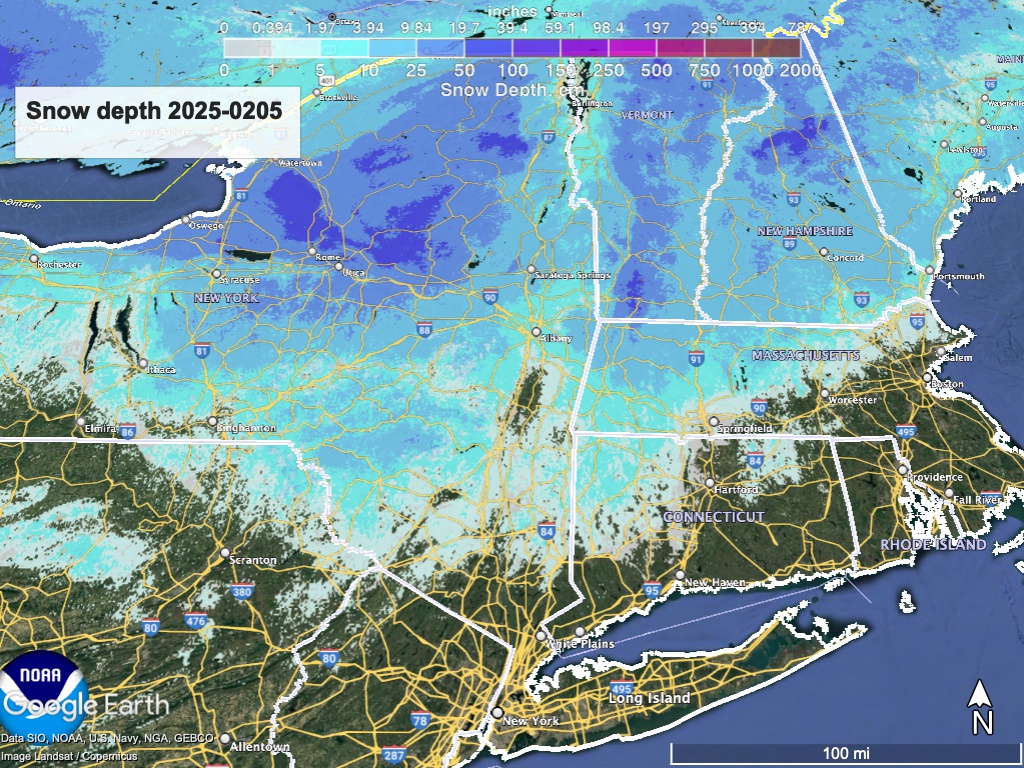
Hit up ‘State of the touring centers‘ or in the menu above for reported conditions as of today. Snow depth graphic below:
Forecast
,We have three opportunities for snowfall accumulation over the next week. Not much for the edownstate, but might lay just enough new snow on a thin base to make it skiable. Elsewhere there have been more rgular refreshes of anywhere from 2″ to a foot. Mother Nature has been building layers of snow on the north country with more to come.
First up, a broad weather event will develop late Wednesday night. It may start as snow, but will change to mixed rain or freezing rain along the coast and NYC metro on Thursday, with snow with wintry mix further north. Moderate accumulation of 4″ of snow possible across the Adirondacks and VT. Friday will feel much colder, with WNW gusty winds up to 30-35mph. Lake effect snow likely across northern NY and VT.

Next, another system moves in on Saturday. Snow and wintry mix up to the southern Adirondacks and southern Vermont. Precipitation more likely to remain snow north of that. This system will move quickly through the region and probably not leave much in accumulation. Weather turns drier and breezy for the end of the weekend and Monday.
Third, the foecast for net Tuesday holds the possibility of snow showers across the northeast, and possibly some accumulation to the lower Hudson Valley and NYC metro overnight Tuesday-Wednesday.
| Daytime temps | Wednesday 2/5 | Thursday 2/6 | Friday 2/7 | Saturday 2/8 | Sunday 2/9 | Monday 2/10 | Tuesday 2/11 |
| Northern NY, VT, NH | Teens to low 20s | High 20s to low 30s | High 20s to low 30s | 20s | High 20s to mid 30s | Mid-20s to low30s | 20s |
| NYC metro and coastal New England | High 20s to low 30s | Mid 30s to low 40s | Mid 30s to low 40s | 30s | High 30s to low 40s | 30s | 30s |
