
High Point got 8″ last weekend and opened trails for skate and classic skiing. The Shawangunks got a decent amount as well.
Today High Point is open and skiable, Minnewaska reports decent skiing, and Mohonk repots all trails are open for skii ng, although no tracks are set. Unfortunately Fahnestock got only 4″ of snow, not enough to open without a pre-existing base. Shawangunk Nordic Ski Association recommends rock skis for the Minnewaska/Mohonk area, and that skiing should continue through the weekend. Yay!º
A bit futher up I-87, Pineridge finally has ‘real snow to play in’ and is open for skiing on about 20k.
But baby it’s cold outside!
With single digits overnight in the NYC metro area, today is the coldest in a long time.
This post is about conditions for Jan. 22 2025, and forecast for the next few days. See jump links to Conditions and Forecast.
How’s the skiing in general?
South of Albany and Vermont or New Hampshire, rock skis advised. Further up north, consider touring skis for those trails that can’t have trasks set. Use the nice and narrow skis for places with great grooming operations.
Places like Garnet Hill and Lapland Lakes normally have more cover at this time of year, but they have enough to grom and set tracks (mostly). This past weekend, areas in the Berkshires, Catskills, and Hudson Highlands got enough of a blast to groom trails, but not quite enough for great track setting. That said, the cold temps will keep conditions going for at least the next few days.
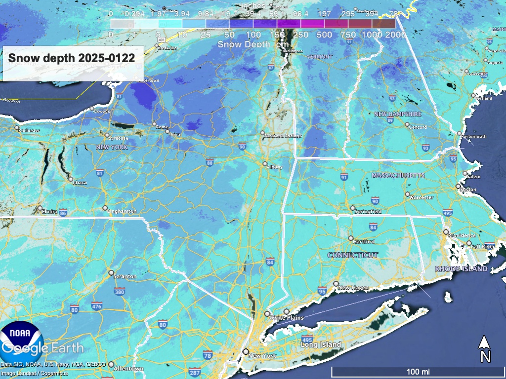
Hit up ‘State of the touring centers‘ or in the menu above for reported conditions as of today. Snow depth graphic below:
Forecast
Light lake effect snow for upstate New York for the remainder of the week. Could bring a few to several inches just east or south of the Great Lakes. Early next week a possible system with light snowfall up north and freezing rain down south. Temperatures will moderate over the course of the week, reaching pleasant but still wintry highs for the weekend and following.
Fortunately not too windy today, but gusts onThursday and Friday could be 15-20mph. In general winds will be light or moderate, for the next few days. Wind gusts will increase in speed to 20-30mph over the weekend and into the beginning of the next week
| Daytime temps | Wednesday 1/22 | Thursday 1/23 | Friday 1/24 | Saturday 1/25 | Sunday 1/26 | Monday 1/27 | Tuesday 1/28 |
| Northern NY, VT, NH | Subzero to teens | Low to mid 20s | Teens to low 20s | Low to mid 20s | Mid 20s to low 30s | Mid 20s to low 30s | Mid 20s to low 30s |
| NYC metro and coastal New England | Teens to low 20s | Mid 20s to low 30s | Mid 20s to low 30s | High 20s to low 30s | 30s | 30s | 30s |
Stay warm!
