

It won’t be a historic storm, but it’s the first winter nor-easterr to hit NYC in about two years.
The storm will drop several inches across the NYC metro and southern New England, with higher amounts just inland. Looks encouraging for Minnewaska Sate Park to groom trails, and possibly enough for Fahnestock Winter Park. Check these siites or email lists for more info tomorrow:
Minnewaska, Mohonk, River to Ridge trail (New Paltz area in Ulster County):
- Hudson Valley NY Skiers (Google group) – Owner of the group usually posts an update, and members will post conditions they experienced.
- Mid-Hudson Valley Cross Country Ski (Google group) – Park staff will post updates to this group. Members will also post about rails in the area, including Mohonk and rail trails in the Mid-Hudson Valley.
- Shawangunk Nordic Ski Association (facebook) is a ski club in the area, and may post conditions for Minnewaska or the River to Ridge trail on facebook.
- Mohonk Mountain House posts trail conditions for the trails on their property.
Fahnestock Winter Park (east of Cold Spring in Putham County)
- Fahnestock State Park web page posts conditions for the Winter Park during the season. Also check FahnestockWinterPark posts on Twitter/X.
- Also check the Google groups above for posts
For some additional details about touring centers, head to the page ‘Touring centers by proximity to NYC‘
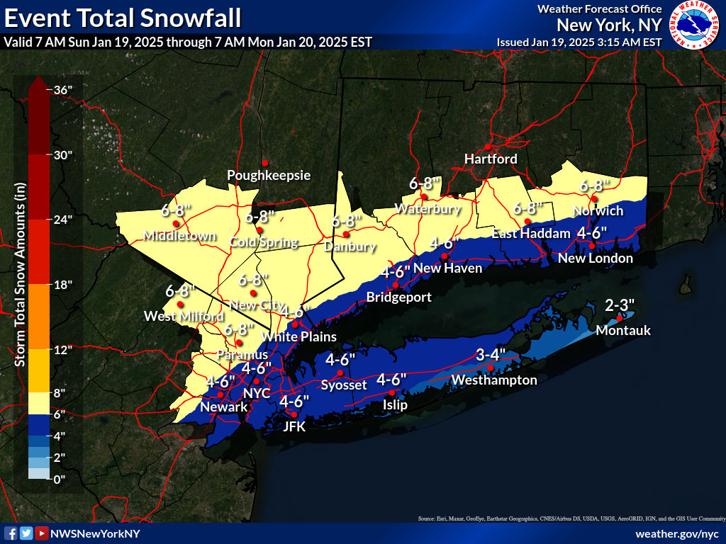
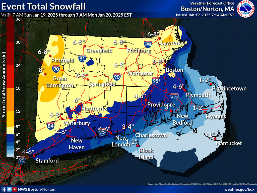
Forecast
4-6″ of snow are exxpected across the NYC metro and southern New England, with greater accumulations just inland from the coast. A welcome refresh of new snow is also in store for the Catskills, southern Vermont, and the lake district of New Hampshire. The other good news is that an arctic air mass will enter the region following the storm, keeping temperatures frosty for a few days.
Below are the expected accumulations across the region:

As forecast earlier, things will get really chilly starting this afternoon. Black ice warning in effect for today. The arctic air mass following the storm’s exit and causing the chill will bring westerly winds for the entire northeast and lake effect snow in the far north. Folks in downstate NY and New England should epare for wind gusts of 30+mph for the next couple of days.
Temperatures and winds will get milder toward the end of the week. Winds will be primarily from the west, and westher will be dry except for a day or so late in the week when there could be a bit of light snow up north.
| Daytime temps | Monday 1/20 | Tuesday 1/21 | Wednesday 1/22 | Thursday 1/23 | Friday 1/24 | Saturday 1/25 |
| Northern NY, VT, NH | Teens | Single digits to teens | Single digits to teens | Teens to low 20s | 20s | Low 20s to low 30s |
| NYC metro and coastal New England | 20s | Teens to low 20s | Teens to low 20s | 20s to low 30s | Low 30s | 30s |
This coming week looks like a good time to be retired or a freelance worker!


High Point XC Ski Center, NJ got 8″ of new snow and groomed 15 km with packed powder for classic and skate skiing and 8 km designated for snowshoeing.
LikeLike