
Colder temps and a scant inch or three of snow make this weekend’s skiing enjoyable. Dress warm though!

Unfortunately the NYC metro area is still out of luck, but good skiing to be had at Prospect Mountain, and minimally skiable trails at Notchview.
This post is about conditions for Dec. 20 2024, and forecast for the next few days. See jump links to Conditions and Forecast.
How’s the skiing in general?
The dusting of snow over the past tow days hit the higher elevations and mountains, particularly in NY and VT, leaving the river valleys and NH except for the White Mountains mostly out of it. The snowfall accumulation graphic shows mostly 1-2″ across the northern elevated areas, with a few small spots in the higher mountains up north getting 3-4″:

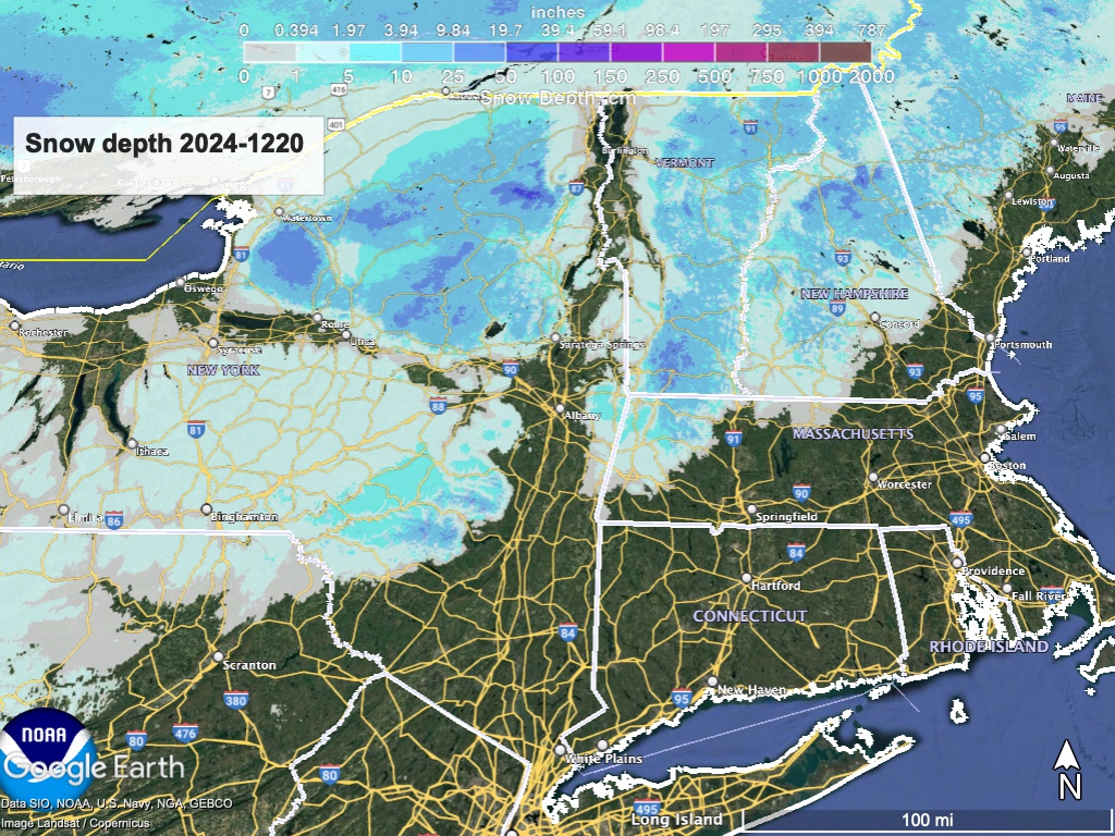
Hit up ‘State of the touring centers‘ or in the menu above for reported conditions as of today. Snow depth graphic below, You can see that the remaining warm and wet weather still took a bite out of the snowpack yesterday:
Coverage may look a bit thin, and not as wide as we’d like, but it’s skiable snow- and before the Christmas holiday too, so no bitchin’. The Tug Hill plateau has made it through the warmth and rain in the best shape, as that area had received four feet of snow over the past two weeks! With the remaining base, a few inches and some grooming will make for excellent skiing.
A small refresh of snow coming for the early part of the weekend. Hard core skiers will head out on Saturday and Sunday, but those who have more work flexibility may defer till Monday or Tuesday when temperatures become more moderate and winds die down.
Forecast for the holiday week
Temperament over temperature- temperatures in the 30s make it brisk, 20s are cool, teens are chilly, single-digits are cold, and only below zero can we say it’s freezing.
For Friday and Friday evening, snow showers likely up north, and possibly also in the southern and coastal regions but mixed with rain. Lingering snow showers will taper off on Saturday. Some lake effect snow can be expected as a result of the cold air arriving this weekend, and this may deposit several inches on the Tug Hill and as far east as the Adirondacks.
This weekend it’s going to be chilly, and up north truly cold! That cold air will be very dry though, so no precipitation expected until next week. Saturday and Sunday will be have breezes of 10-15mph, and given the cold temperatures it could feel a bit brutal outside.
By Tuesday (Christmas Eve) the weather warms up, and some possible snow showers arrive as well, potentially leaving some (more) of us with a white Christmas (not be be confused with a White Christmas). Total accumulation looks to be light or insignificant at this time, but who knows?
For the midweek days of Christmas and Boxing Day, temperatures continue on an upward trend. We’ll have to see what the weather brings for the end of the week and further when forecasts bceome clearer.
| Daytime temps | Friday 12/20 | Saturday 12/21 | Sunday 12/22 | Monday 12/23 | Tuesday 12/24 | Wednesday 12/25 | Thursday 12/26 |
| Northern NY, VT, NH | Mid 20s to low 30s | Teens to mid 20s | Single-digits to teens | Tees to mid 20s | High 20s to low 30s | 30s | 30s |
| NYC metro and coastal New England | Low 30s to low 40s | High 20s to mid 30s | Low to mid 20s | High 20s to low 30s | Mid 30s to low 40s | Mid 30s to low 40s | High 30s to low 40s |
Stay tuned and thanks for reading. Go skiing!
