
Fortunes could change for a few locations following this weekend. For others, this is waiting in the wings:
There’s a tantalizing possibility that a few areas will get enough snow to groom or reopen by the weekend. The weather in the early part of next week will be cold enough to support a snowpack if any remains. Read on for details, but keep expectations on a short leash.
This post is about conditions for Mar. 15 2024, and forecast for the next few days. See jump links to Conditions and Forecast.
Conditions
Very thin cover in the valleys. It was firm and fast in the mornings, soft and wet during the day until today. With light rain, it’s now slushy and slow, with many wet and bare spots. The one place known to have snow right now is Gret Glen, where several inches of wet snow have fallen.
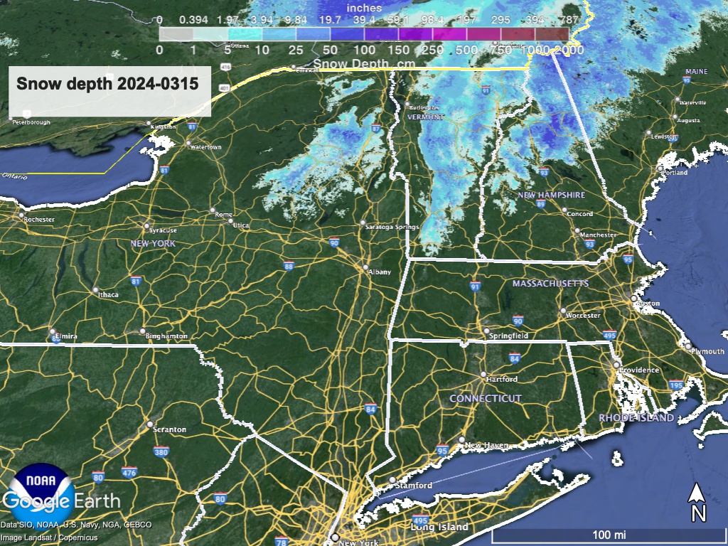
Hit up ‘State of the touring centers‘ or in the menu above for reported conditions as of today. Snow depth graphic below:
Forecast
Temperatures above normal until the latter half of the weekend when they will drop below normal. Moderate rain showers Friday, and a dry period Saturday before another system from the midwest brings rain on Sunday. Cooler temperatures for the first part of next week could leave snow behind in far northern areas of New York State and New England.
Rain showers late Thursday overspread the entire northeast US overnight into Friday, with some heavier rainfall primarily in the northern areas. Up to 1″ total predicted. Far northern regions at higher elevations (Adirondack High Peaks, Vermont’s Northeast Kingdom, New Hampshire’s White Mountains) could see slushy snow or wintry mix, mainly above 2500′. Precipitation from this system will end by mid-day Saturday.
Late Saturday night, a system arriving from the midwest brings more rain, with possible snow on Sunday for those same far northern and elevated localities as the previous system. Light accumulations anticipated for this system. Expect breezy conditions along with the below-normal temps on Sunday.
For the first half of next week, cold air from Canada will cause temperatures to stay on the cool side for this time in the season, and remaining breezes from the weekend low will cause lake-effect precipitiation across all of New York State and portions of New England. Due to the cold, there could be periods of snow showers in the northern areas.
By the latter part of the week temperatures will once again rise to normal or above-normal.
Forecast highs:
| Daytime temps | Friday 3/15 | Saturday 3/16 | Sunday 3/17 | Monday 3/18 | Tuesday 3/19 | Wednesday 3/20 | Thursday 3/21 |
| Northern NY, VT, NH | 40s | 40s? | Mid 40s to low 50s | High 30s to low 40s | 30s | Mid 30s to low 40s | Mid 30s to mid 40s |
| NYC metro and coastal New England | 60s | 50s? | Mid 50s to low 60s | 40s | 40s | 40s | High 40s to low 50s |
And lows:
| Low temps (early AM on date) | 3/15 | 3/16 | 3/17 | 3/18 | 3/19 | 3/20 | 3/21 |
| Northern NY, VT, NH | Low 30s to low 40s | High 20s to mid 30s | 30s | Mid 20s to low 30s | 20s | 20s | |
| NYC metro and coastal New England | Mid 40s to low 50s | Mid 30s to low 40s | Low- to mid-40s | Mid 30s to low 40s | High 20s to mid 30s | High 20s to mid 30s |
