
When updates lag, you know the touring centers are losing hope for the season. It looks like I won’t be needing this:

But there’s still some hope- read on for more.
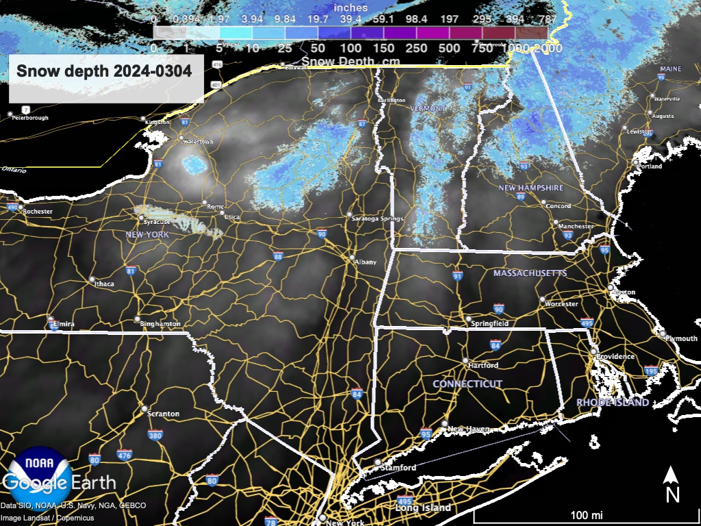
This post is about conditions for Mar 4 2024, and forecast for the next few days. See jump links to Conditions and Forecast.
Conditions
This year the White Mountains have gotten the best of a meager snowpack, but now the touring centers in the Presidentials are having marginal conditions.
BETA report on conditions as of 3/3 is ‘sort of’
Hit up ‘State of the touring centers‘ or in the menu above for reported conditions as of today. Snow depth graphic below:
Forecast
Light rain along the New England coast tonight. A moisture-laden system moving up the mid-Atlantic coast will overspread the northeast by midday Tuesday bringing rain, After a short respite another ‘unsettled’ weather system sets in on Wednesday into Thursday bringing more rain, and heavy rain is likely. Some conversion to slushy snow could happen in the far north during the night time hours. For people in the northeen areas, some caution for driving during the the early. morning hoursof Wednesday and Thursday is advisable.
But wait- there’s more! A high-pressure system from the north will move in for the weekend, and is predicted to mix with a low pressure system from the south and west. We can expect some rain for the first part of the weekend. And while NWS forecasts are uncertain for now, there’s a possibility of some S-N-O-W higher elevations inr the Catskills, Adirodacks, Vermont and New Hampshire late Sunday or early Monday.
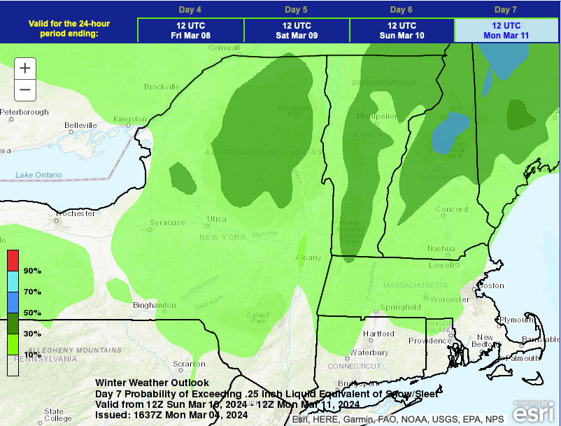
The NWS Weather Prediction Center puts slightly less than 50% chance of some accumulation of snow or sleet in the Adirondacks and Green Mountains by next Monday. The Presidential range of the White Mountains has something like a 60% probability. Converting 0.25″ of water to snow accumulation at a standard ratio of 10:1 would make for 2.5″ of snow. Not a lot but there’s hope the forecast will move in the direction of more snowfall.
| Daytime temps | Tuesday 3/5 | Wednesday 3/6 | Thursday 3/7 | Friday 3/8 | Saturday 3/9 | Sunday 3/10 | Monday 3/11 |
| Northern NY, VT, NH | Mid 40s to low 50s | High 40s to high 50s | Mid 30s to mid 40s | High 30s to mid 40s | High 30s to mid 40s | High 30s to low 40s | Mid 30s to low 40s |
| NYC metro and coastal New England | High 40s to low 50s | High 50s | High 40s to low 50s | High 40s to low 50s | Mid- to high-40s | Mid- to high-40s | Mid-40s |
Low temps:
| Low temps (early AM on date) | 3/5 | 3/6 | 3/7 | 3/8 | 3/9 | 3/10 | 3/11 |
| Northern NY, VT, NH | Mid 30s to low 40s | Mid 30s to low 40s | Mid 20s to mid 30s | Low 20s to low 30s | Low 20s to low 30s | Mid 20s to low 30s | Low 20s to low 30s |
| NYC metro and coastal New England | Low 40s | Low- to mid-40s | Mid- to high-40s | Mid- to high-30s | Mid 30s to low 40s | Mid 30s to low 40s | 30s |
