
Uh-oh. Warning signs of spring have been sighted:
- Maple sugaring has started.
- NWS issues snowmelt flooding warnings (although with the thin snowpack it’s not much of a warning).
- Mud season alerts.
- Volunteer-groomed and shoestring-budget trail operations are winding down for the season.
Prospect Mountain is still decent, as are other trails with daily grooming. The Whie Mountains are still good, and Gaarnet Hill is putting in a diligent effort, as is Lapland Lake.
This post is about conditions for Feb. 26, 2024, and forecast for the next few days. See jump links to Conditions and Forecast.
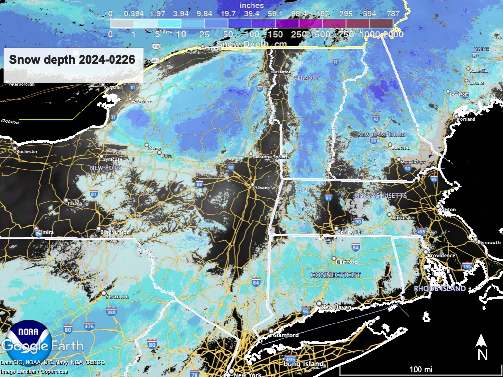
Conditions
Spring skiing for Monday and Tuesday. The northern Adirondacks and Vermont received up to an inch of snow that helped refersh trails, but it won’t last long. Cool nights and warm days ahead mean Spring Skiing. If this were a season with a good snowpack, this could be great.
Unfortunately we have a couple of very warm and rainy days ahead. Apart from the rain and warmth during daytime, the above-freezing nighttime temps pose a real risk for the remaining snowpack. In regard to skiing, Magic 8-ball says: ‘check back later’, probably Friday afternoon to see what’s left after rain and a hard refreeze.
Hit up ‘State of the touring centers‘ or in the menu above for reported conditions as of today. Snow depth graphic below:
Forecast
Rain arrives Tuesday afternoon, growing steadier into the evening. as it overspreads the northeast and mid-Atlantic states. Rain continues through Wednesday before tapering off as cold air arrives, with a brief changeover to snow in northern areas before the front departs.
Light winds from the south for the early part of the week, getting stronger (20+mph) by Wednesday and shifting out of the west as the cold air arrrives for Thursday. A bit of lake effect snow in upstate New York may result from the incoming front, but it will be short-lived..
Dry and mild weather is forecast for the end of the week, with some showers in the southern area of the northeast near the NYC metro and Long Island late in the weekend or early next week. Light breezes from the SSW shifting to east.
| Daytime temps | Tuesday 2/27 | Wednesday 2/28 | Thursday 2/29 | Friday 3/1 | Saturday 3/2 | Sunday 3/3 | Monday 3/4 |
| Northern NY, VT, NH | Low- to mid-50s | Mid- to high-50s | Mid 20s to low 30s | High 30s to low 40s | Low 50s | 50s | Mid-20s to high-30s |
| NYC metro and coastal New England | Mid- to high-50s | High 50s to low 60s | High 30s to low 40s | Mid- to high-40s | Low 50s | 50s | Mid- to high-40s |
Adding the nighttime lows for decision suport for morning skiing, especially later this week:
| Low temps (early AM on date) | 2/27 | 2/28 | 2/29 | 3/1 | 3/2 | 3/3 | 3/4 |
| Northern NY, VT, NH | Mid- to high-20s | Low- to mid-40s | Teens to high 20s | Teens | High 20s to low 30s | 30s | Mid 30s |
| NYC metro and coastal New England | Low 30s to low 40s | Mid- to high-40s | High 20s to mid 30s | Mid 20s to low 30s | 39s | High 30s to low 40s | Low 40s |
