
“It ain’t over till it’s over” – Fahnestock is skiable and High Point has good skiing.
We didn’t get the storm we hoped for, but we have two more chances for a good holiday weekend. Let’s take a look at where the snow fell on Tuesday.

The heaviest accumulation clustered near the coastline of northern New Jersey, the NYC metro, and Connecticut. Sharp fall off north of Putnam county in New York and the CT/MA border left the Hudson Highlands and Berkshires high and dry. Interestingly, isolated locations in the north country got a few inches of powder, but this fell on ice so it didn’t really help conditions so much.
This post is about conditions for Feb. 14, 2024, and forecast for the next few days. See jump links to Conditions and Forecast.
Conditions
The snow depth shown for the NYC metro and southern New England area in the graphic below matches the snowfall of Feb. 13 in the graphic above, naturally. Across the entire northeast cover is broad but thin. Crucially the cover up north is old and icy, while the cover down south is new but without a base. We’ll take what there is, and of course wish for better.
The White Mountains continue to have the best conditions overall, and the small amounts of snow that fell on the southern Adirondacks and central Vermont definitely helped out. The track of the Tuesday storm totally left out the Catskills or Berkshires. Here’s what the snow dept his like today:

Forunately we’ve got another spin at the weather wheel, and this time it’s the north country’s turn. See forecast below. Hit up ‘State of the touring centers‘ or in the menu above for reported conditions as of today.
Forecast
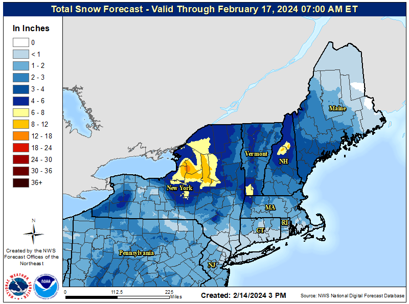
Expect a breezy President’s Day weekend, with winds ranging from 10-20mph, higher in gusts. If you’re heading to the north country for the weekend you’ll likely be driving through some snow. There are two systems heading to the region:
First snow arrives in the northeast Thursday midday, and by the evening commute we may be seeing flurries in NYC and snow from the mid-Hudson Valley northward. Snow will intensify Thursday evening from the Hudson Highlands all the way to the Canadian border. Snowfall will gradually retreat northward through Friday morning.
But wait- there’s more. Friday evening another system brings snow showers to the region, and light snow could continue for the north country through the day on Saturday, leaving lake-effect snow lingering for the Adirondacks and northern Vermont on Sunday.
Altogether, there’s a 70% probability of more than 4″ of snow accumulating in theAdirondacks and Green Mountains by Saturday. The Tug Hill plateau has a high probability of getting 8″ of snow. Accumulations will be mainly in northern New York State and New England. Lower elevations of the region may get an inch or three.
The end of the holiday weekend will also mark the end of seasonably cool temperatures, and a warming trend will bring springlike daytime temperatures. Carpe diem.
| Daytime temps | Thursday 2/15 | Friday 2/16 | Saturday 2/17 | Sunday 2/18 | Monday 2/19 | Tuesday 2/20 | Wednesday 2/21 |
| Northern NY, VT, NH | High 20s to mid 30s | High 20s to mid 30s | Mid 20s to mid 30s | High 20s to low 30s | Mid 20s to mid 30s | High 30s to high mid 40s | Mid 40s to low 50s |
| NYC metro and coastal New England | Mid 30s to low 40s | Mid 30s to low 40s | 30s | mid- to high-30s | High 30s to klow 40s | 40s | High 40s to low 50s |
