
Rapid and significant snowstorm to leave snow in the northeast from nighttime Monday 2/12 through Tuesday 2/13. Periods of freezing rain or heavy snow may impact Tuesday morning commute in the NYC metro area and lower Hudson Valley. 4-8″ of ‘plowable’ snow could accumulate in the area, more in certain locations.

Bonus: keep an eye on weather for President’s Day weekend! This post is about conditions for Feb. 11, 2024, and forecast for the next few days. See jump links to Conditions and Forecast.
Conditions
Current ski trail conditions have been firm to icy in the morning, and granular to springlike during the day. As expected, cover has been getting thin, so touring centers have cut back on grooming or closed trails to preserve the snowpack. BETA report of 2/11 paints a grim picture for backcountry skiers in the High Peaks,with skiable terrain above 2800′.
If the coming storm delivers the expected snowfall, we can expect Minnewaska, Mohonk and High Point to groom and reopen ski trails by afternoon Wednesday or Thursday morning. It’s possible that Fahnestock will get enough snow to open the trails.
Other places that could make out well are the in the area of heaviest accumulation, which includes the Catskills, Berkshires, and southern Vermont and New Hampshire. Once again, the far north won’t be getting much from Mother Nature during the first half of the week.
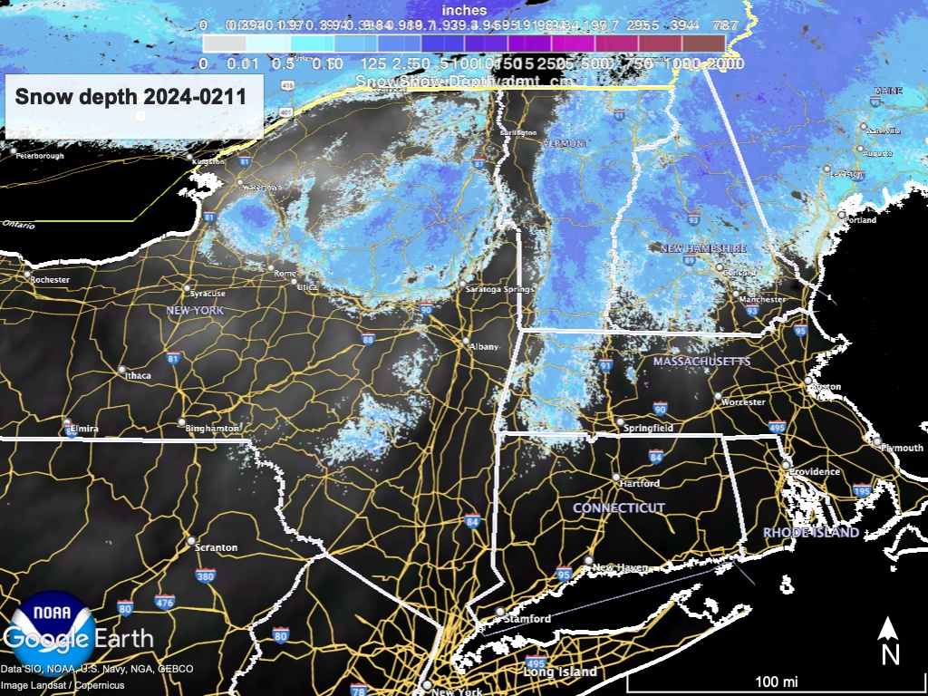
Hit up ‘State of the touring centers‘ or in the menu above for reported conditions as of today. Snow depth graphic below shows a snowpack that looks more like early to mid-March.
Forecast
We have a cooler, cloudier, and snowier week ahead, with multiple possible snow events. Wind shells will be needed. The immediate event is a fast-moving storm with a shifting storm track. Currently expecting 4-8″ of snow in the immediate NYC metro area, 8-12″ slightly north or inland. Snow acccumuations will drop off rapidly north of the Hudson Highlands and I-90, but a few inches could still fall across the Catskills and southern Vermont and New Hampshire.
Starting late Monday night, a fast-moving system will go through the region. While forecasts seem definite that heavy snow can be expected for a short time, total accumulations will vary significantly by local conditions. The immediate NYC metro area could start with rain or wintry mix, and eventually get 4-8″ of snow, while the area just further north and inland could receive a foot. Expect variations of several inches in the total accumulation for this storm.
Because the projected storm track has shifted more southerly, this is turning into a coastal snowstorm., and accumulation will drop off quickly to the north. It’s still likely that the region up to the Catskills and I-90 could get over 8″ of snow, but totals will drop to a few inches just over the Vermont and New Hampshire border. However, Boston could see the biggest snowstorm of the season.
The storm will increase intensity early Tuesday, and some spots could experience heavy snowfall rates for brief periods of time. Winds will be 15-25mph. The lower Hudson Valley can expect messy, possibly hazardous driving conditions Tuesday morning. The storm will move out of the region by Wednesday early morning.

For the rmidweek, winds from the west-northwest and weak weather systems will keep temperatures seasonably cooler and cloudy with potential snow showers. Breezes during Wednesday and Thursday of 10-15mph.
For President’s Day weekend, more good news could be in store: two relatively weak systems, one from Canada and the other from the Midwest, could combine to produce additional snow showers from Friday through Sunday. Winds will be much stronger at times,15-25mph on Friday and Saturday. Stay tuned as confidence in the forecast is low.
| Daytime temps | Monday 2/12 | Tuesday 2/13 | Wednesday 2/13 | Thursday 2/14 | Friday 2/15 | Saturday 2/16 | Sunday 2/17 |
| Northern NY, VT, NH | Mid 30s to low 40s | High 20s to low 30s | Teens to high 20s | Mid 20s to low 30s | High 20s to mid 30s | Mid 20s to low 30s | High 20s to mid 30s |
| NYC metro and coastal New England | 40s | 30s | 30s | Mid 30s to low 40s | HHigh 30s to low 40s | 30s | High 30s to low 40s |
