
Ski in the present, go with the flow, Hope for the best. ‘be water’.
If you can only do a short trip, ski Upper Awosting at Minnewaska Otherwise head to Prospect Mountain, Garnet Hill, and maybe Osceola Ski and Sport. This post is about conditions for Feb. 8, 2023, and forecast for the next few days. See jump links to Conditions and Forecast (updated Friday 2/9).
Conditions
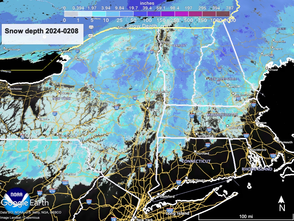
Get the skiing in before the weekend. Otherwise, wait it out and hope for a good snowfall somewhere. The snow depth graphic shows the overall lack of snow, a real buzzkill for what should be the meat of the season. Incidentally it also illustrates the near-heroic job at Minnewaska to keep even one trail groomed.
The touring centers with eat best equipment and groomers have conditions that are firm with a loose granular surface; firm in the morning and softening as the day goes on. Places like Prospect Mountain, Garnet Hill, and the areas in the White Mountains can do it because their cover is decent right now. Thinner cover means less that to work with. That or less attentive grooming means things are icier in general.
Everything changes once the weekend arrives with very warm temps and rain in the forecast. If that happens, touring centers will likely close trails to preserve the base, hoping for a refresh early next week.
Hit up ‘State of the touring centers‘ or in the menu above for reported conditions as of today. Snow depth graphic below:
Forecast
The weekend will be warm, and wet in the first half. Rain showers starting in western New York State early Saturday will spread over the northeast by mid-day, with some areas of heavier rain from the finger lakes through the Adirondacks and northern Vermont. Rain in those areas could convert to snow overnight. Sunday will be dry, once lingering precipitation clears out..
Monday is when things get interesting. Temperatures begin to cool as a low pressure region moves in from the south and west. The consensus of NWS forecast offices shows low confidence in predictions regarding the track of the low and consequent amount and type of precipitation. This does not appear to have the makings of a major storm but I”ll be glad to be proven wrong. That said, the below summarizes what the NWS forecasts right now.
For Monday the rain/snow line will run from the Catskills across the Berkshires toward the lake district of New Hampshire. Given a possibility of wintry mix across a wide area, driving could be hazardous on Monday across the interior of northern New Jersey, northeast Pennsylvania, and the southern tier of New York
Friday 2/9 update in bold:
The snow line may advance southward on Tuesday, with snow showers touching the NYC metro area and New England coast before retreating back to linger in the north country through Wednesday. Greatest accumulation likely to be more southerly than previous forecast models, from the PA/NJ/NY border through southwestern Massachusetts and possibly southern Vermont. Total accumulations are expected to be small.
By midweek, a slight chance of some snow showers across western and northern New York, Vermont and New Hampshire.
| Daytime temps | Friday 2/9 | Saturday 2/10 | Sunday 2/11 | Monday 2/12 | Tuesday 2/13 | Wednesday 2/14 | Thursday 2/15 |
| Northern NY, VT, NH | Mid 40s | High 40s to low 50s | Mid 30s to mid 40s | Mid 30s to low 40s | Mid 20s to mid 30s | 20s | 20s |
| NYC metro and coastal New England | High 40s to low 50s | 50s | High 40s to low 50s | low- to mid-40s | High 30s to low 40s | 30s | 30s |
