
Klister and rock skis recommneded for Minnewaska, where selected trails were groomed Sunday. Elsewhere, decent to good skiing, so get it while it’s there.

Year of the Wood Dragon starts Feb. 10, and this weekend we’ll see rain followed by wet snow or mixed precipitation. Early in the following week, snow for the north country could be coming to refresh and change conditions again. XC skiers will be busy changing skis, technique and wax to suit the conditions.

This post is about conditions for Feb. 5, 2023, and forecast for the next few days. See jump links to Conditions and Forecast.
Conditions
Enjoy dry, sunny, and seasonable temps for a couple of days before a warming trend and an incoming low system rain on the parate late in the week.
Wide range of trail conditions early this week- from ice and rock ski conditions at Minnewaska to hard wax classic conditions at Great Glen. Surface will be firm and fast in the mornings, with softening trails in the afternoon. Quality of grooming and luck with available snowpack makes the difference between ‘good skiing’ and ‘skiable’ conditions.
From midweek on, temperatures will rise. Skiing might be easier but cover will be thinner. Keep an eye on the forecast for early next week.
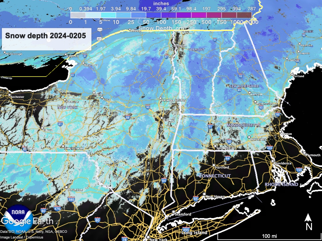
Hit up ‘State of the touring centers‘ or in the menu above for reported conditions as of today. Snow depth graphic below:
Forecast
Clear skies ans seasonably ‘normal’ temperatures to bein with, then a warming trend and dry weather for most of the coming week. Offshore snow may touch the coastal areas of Massachusetts, New Hampsire and Maine during the first part of the week.
Relatively weak low pressure system from the midwest mixes with a cold front and brings rain showers starting on Friday. Northernmost elevated t areas may see snow or some freezing rain before changeover to all rain by Saturday. Precipitation may convert to all snow for the north coutnry areas of the Adirondacks, Vermont, New Hampsure and Maine by end of day Sunday. Total amounts of rain or snow should not be significant.
Early next week, a mix of systems may bring unsettled weather and precipitation to the northeast as temperatures begin trending downward. Something to keep an eye on, but no predictions yet.
| Daytime temps | Monday 2/5 | Tuesday 2/6 | Wednesday 2/7 | Thursday 2/8 | Friday 2/9 | Saturday 2/10 | Sunday 2/11 |
| Northern NY, VT, NH | Mid 20s to mid30s | High 20s to mid 30s | High 20s to high 30s | Low 30s to low 40s | Low 30s to low 40s | Low 40s to low 50s | High 30s to low 40s |
| NYC metro and coastal New England | High 30s to low40s | High 30s to low40s | 40s | High 40s | High 40s | 50s | High 40s to low 50s |
