
Summary: local XC skiing is alive for the NYC metro; ‘rock skis’ advisory in effect. High Point is open with grooming but no tracks. Minnewaska groomed 1/20 and is regrooming some trails today. Mohonk has all trails open and rolled but no tracks. SNSA says the River-to-Ridge trail is surprisingly decent, but cover is a bit thin and there are patches of open gravel in sections near New Paltz.
This post is about conditions for Jan 22 2024, and forecast for the next few days. See jump links to Conditions and Forecast.
Conditions
The determined folks at the touring centers near the NYC area have been hard at work keeping tht trails groomed. Cold temps over the weekend helped preserve the base, and across much of the northeast conditions are ‘machine groomed’.
Slightly farther from downstate, Prospect Mountain is very good, the areas in the Berkshires have good skiing, and Garnet Hill and Lapland Lake have good conditions.
Best snow is in the Tug Hill area of New York and the White Mountains of New Hampshire. Random weather pattterns have left the High Peaks with a bit less snow than one would normally expect. BETA report of 1/21 is a bit skeptical about backcountry, but has added a report on Scott’s Cobble trails, a groomed system that was taken on by High Peaks Cyclery.
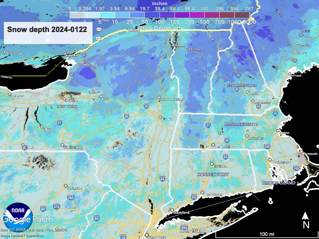
Hit up ‘State of the touring centers‘ or in the menu above for reported conditions as of today. Snow depth graphic below:
Forecast
Having just had temps in the teens to single-digits, what will it be like having highs in the 40s? Balmy. Night time temperatures will be above freezing for the latter part of the week, not dipping below feezing until early Sunday morning.
Light lake-effect snow spreads across northern NY State and northern VT and NH Monday evening. A few inches may accumulate in the north country of NY and New England.
An unsettled weather pattern will dominate the northeast during the middle and latter parts of the week. Altogether there could be significant precipitation in some parts, falling mostly as rain.
One event starts Tuesday, bringing light snow, ice, wintry mix, and rain to the northeast. Over the course of Wednesday through Thursday, the closely following second event willchange precipitation to rain for most of the northeast with the exception of northern New Hampshire and Maine. By Friday even those areas will get rain as well.
Cold air arrives next weekend and may change light rain showers on Saturday to light snow showers for the region north of Albany and Massachusetts.
| Daytime temps | Monday 1/22 | Tuesday 1/23 | Wednesday 1/24 | Thursday 1/25 | Friday 1/26 | Saturday 1/27 | Sunday 1/28 |
| Northern NY, VT, NH | Mid 20s to low 30s | High 20s to mid 30s | 30s | Mid 30s to low 40s | Mid 30s to high 40s | Mid 30s to low 40s | High 20s to mid 30s |
| NYC metro and coastal New England | 30s | High 30s to low 40s | High 30s to low 40s | Mid 40s to low 50s | High 40s to high 50s | Mid 40s to low 50s | High 30s to low 40s |
