There are larger trail systems and more spectacular views in some trails out west, but the Northeast US has the most dense concentration of cross-country ski areas and trails of any region. Northeasterners get really nice views as well from some places (Minnewaska, Great Glen), and a sense of speed from skiing in the trees.
The combined Google map below features many, but by no means all, of the parks and ski areas available for cross-country skiing within a day’s drive of NYC. See the List of Touring Centers or Nearby Parks and Trails for additional info. Many parks and golf courses permit skiers in winter; check specifically or with some cross-country skier groups for suggestions.
The best outdoors is the one right outside your door.
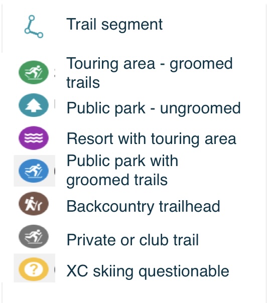
Icon use for the legend uses the best matching Google map icon for activity and place labels:
- Line segment icon, light blue background- a segment of a trail. Used for some southern Westchester trails.
- XC skiing icon, green background – Touring area with groomed trails. Best choice for beginners.
- XC skiing, light blue background – Public park with groomed trails. Often a choice for locals. Grooming can be a bit irregular.
- XC skiing, grey background – Private or club trail. Public access may be allowed on a limited basis.
- Tree symbol for park, light blue background – Public park, golf course, or rail trail with ungroomed trails. Terrain usually pretty accommodating, but quality of skiing very dependent on weather and who is using the trail.
- Waves of water symbol for spa, purple backbround – Resort with touring center. Best choice for vacations and other activities besides skiing.
- Hiker symbol, brown background – Backcountry trailhead. Rougher terrain that is usually not for beginners. Often requires wider metal-edge skis, backcountry techniques, and patience.
- ‘?’ symbol, yellow background – Ski area where XC skiing may or may not be permitted.